Inscription
Washington-Rochambeau Revolutionary Route National Historic Trail
Our nation never had more at risk than it did in September 1781. The American Revolutionary War—the War for Independence—had raged for nearly six years. More than 4,000 American and French troops, allied in their fight against the British, had marched from New York and inundated Baltimore for four days before advancing toward Yorktown, Virginia. At that time, Baltimore was a city of less than 10,000 residents. One regiment, the Soissonnais of French forces, was encamped at this site. Across the harbor to the east, the Royal Deux-Points, a German regiment under France, camped along Harford Run (Central Avenue) in Jonestown. Others were situated along the Jones Falls, or what is now North Charles Street. The French Cavalry, artillery, and baggage train camped just to the north of Market, now Baltimore Street between Paca and Howard Streets. A brigade of American troops rested at Fells Point. Three Baltimore Town landmarks, St Paul's Church (top), Fite's Tavern (upper left) and the City Courthouse (upper right) are also featured in this scene. Two days after hearing how a French naval fleet overcame the British at the Battle off the Capes in Virginia, the allied forces departed from Baltimore on September 15.
The defeat of British forces at the Battle of Yorktown in October was pivotal. On October 19, 1781, British commander Lord Charles Cornwallis surrendered his army to General George Washington. Within two years, the Treaty of Paris ended the War. America had emerged with its independence.
Details
| HM Number | HM17EC |
|---|---|
| Series | This marker is part of the The Washington-Rochambeau Route series |
| Tags | |
| Historical Period | 20th Century, 19th Century, 18th Century |
| Historical Place | Town |
| Marker Type | Historic District |
| Marker Class | Historical Marker |
| Marker Style | Free Standing |
| Marker Condition | No reports yet |
| Date Added | Wednesday, September 10th, 2014 at 11:39pm PDT -07:00 |
Pictures
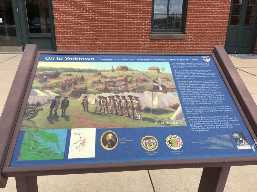


Photo Credits: [1] SEPTEMBERSPARROW1666 [2] SEPTEMBERSPARROW1666
Locationbig map
| UTM (WGS84 Datum) | 18S E 360270 N 4349634 |
|---|---|
| Decimal Degrees | 39.28481667, -76.62013333 |
| Degrees and Decimal Minutes | N 39° 17.089', W 76° 37.208' |
| Degrees, Minutes and Seconds | 39° 17' 5.3400" N, 76° 37' 12.4800" W |
| Driving Directions | Google Maps |
| Area Code(s) | 410, 443, 301 |
| Can be seen from road? | No |
| Is marker in the median? | No |
| Closest Postal Address | At or near 301 W Camden St, Baltimore MD 21201, US |
| Alternative Maps | Google Maps, MapQuest, Bing Maps, Yahoo Maps, MSR Maps, OpenCycleMap, MyTopo Maps, OpenStreetMap |
Is this marker missing? Are the coordinates wrong? Do you have additional information that you would like to share with us? If so, check in.
Nearby Markersshow on map
Maintenance Issues
- Who or what organization placed the marker?
- Which side of the road is the marker located?
Comments 0 comments