Inscription
The path to freedom led this way for slaves fleeing the South in the years before the Civil War. Here, they were given haven and helped along their journey by local people, through one of the key stations on the Underground Railroad, in a house on Baker Alley.
Details
| HM Number | HM2A |
|---|---|
| Tags | |
| Historical Period | 19th Century |
| Historical Place | Other |
| Marker Type | Other |
| Marker Class | Historical Marker |
| Marker Style | Free Standing |
| Year Placed | 1996 |
| Placed By | The City of Uniontown — Bicentennial Committee 1996 |
| Marker Condition |  10 out of 10 (1 reports) |
| Date Added | Tuesday, September 30th, 2014 at 6:00am PDT -07:00 |
Pictures
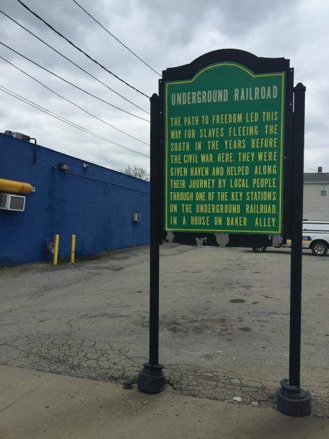
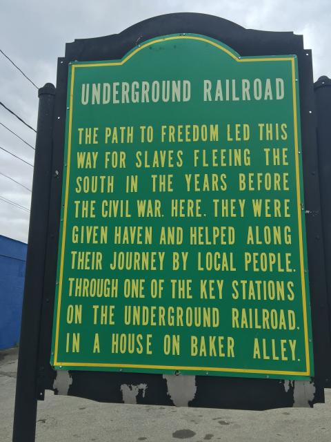

Photo Credits: [1] HARTSEKFAMILY
Locationbig map
| UTM (WGS84 Datum) | 17S E 609831 N 4416981 |
|---|---|
| Decimal Degrees | 39.89617900, -79.71554700 |
| Degrees and Decimal Minutes | N 39° 53.7707', W 79° 42.9328' |
| Degrees, Minutes and Seconds | 39° 53' 46.2444" N, 79° 42' 55.9692" W |
| Driving Directions | Google Maps |
| Area Code(s) | 412, 724 |
| Can be seen from road? | Yes |
| Is marker in the median? | No |
| Which side of the road? | Marker is on the right when traveling North |
| Closest Postal Address | At or near 325 E Main St, Uniontown PA 15401, US |
| Alternative Maps | Google Maps, MapQuest, Bing Maps, Yahoo Maps, MSR Maps, OpenCycleMap, MyTopo Maps, OpenStreetMap |
Is this marker missing? Are the coordinates wrong? Do you have additional information that you would like to share with us? If so, check in.
Nearby Markersshow on map
I Saw The Marker
There is a new marker that is green rather than the blue one from 1996. There is nothing else from that era visible. This just marks the site of the alley in Uniontown, PA
Jul 17, 2016 at 4:08pm PDT by hartsekfamily
Maintenance Issues
- Is this marker part of a series?
Comments 0 comments