Inscription
1868-1896
Normandale was named for Norman W. Dodge, one of seven sons of William E. Dodge, for whom Dodge County was named in 1870. The home of over 500 people, Normandale was headquarters of the Dodge Land & Lumber Company which was established after the Civil War using questionable deeds. The company claimed over 300 square miles of the finest longleaf yellow pine in the world. The area included the counties of Telfair, Dodge, Laurens, Montgomery, and Pulaski. Settlers had earlier claimed most of the property. After years of controversy, the Dodge Company appealed to the federal court and was awarded lands it had seized after the Civil War. As the Dodge Company evicted settlers, a bitter land war ensued. The Dodge superintendent, John C. Forsyth, was shot and killed on October 7, 1890. The murder occurred either in the executive house, now restored, or in a nearby twin structure which burned. Mr. Forsyth and his daughter, Nellie, are buried in the front yard of Christ Church on St. Simons Island. On September 9, 1892, the big mill and dry house of the lumber company burned to the ground. Having depleted the region's forests, the company did not rebuild what was one of the largest saw mills in the south.Details
| HM Number | HM12TY |
|---|---|
| Series | This marker is part of the Georgia: Georgia Historical Society/Commission series |
| Tags | |
| Marker Number | 045-3 |
| Year Placed | 1994 |
| Placed By | Georgia Department of Natural Resources |
| Marker Condition | No reports yet |
| Date Added | Tuesday, September 23rd, 2014 at 12:23am PDT -07:00 |
Pictures


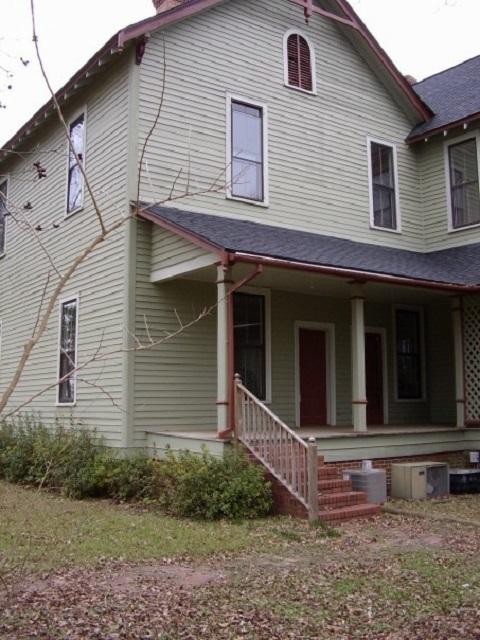


Photo Credits: [1] DANE MARTINDALE
Locationbig map
| UTM (WGS84 Datum) | 17S E 306729 N 3553554 |
|---|---|
| Decimal Degrees | 32.10178333, -83.04823333 |
| Degrees and Decimal Minutes | N 32° 6.107', W 83° 2.894' |
| Degrees, Minutes and Seconds | 32° 6' 6.42" N, 83° 2' 53.64" W |
| Driving Directions | Google Maps |
| Area Code(s) | 229 |
| Closest Postal Address | At or near 8990 McRae Hwy, Chauncey GA 31011, US |
| Alternative Maps | Google Maps, MapQuest, Bing Maps, Yahoo Maps, MSR Maps, OpenCycleMap, MyTopo Maps, OpenStreetMap |
Is this marker missing? Are the coordinates wrong? Do you have additional information that you would like to share with us? If so, check in.
Nearby Markersshow on map
Maintenance Issues
- What historical period does the marker represent?
- What historical place does the marker represent?
- What type of marker is it?
- What class is the marker?
- What style is the marker?
- Can this marker be seen from the road?
- Is the marker in the median?
Comments 0 comments