Inscription
[Roundup of 9 June 1944]
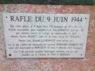
Sur cette place, le 9 Juin 1944, 179 hommes de 18 ? 40 ans furent rassembl puis transf?r en Allemagne par des SS qui avaient investi le village en reprailles et d?j? abattu Pierre Marty pr de la route basse de Poilhes.Parmi eus, Joseph Leibowitz n'en revint pas. Le 6, un convoi de ristants du secteur Poilhes-Capestang avait ?t? intercept? ? Fontjun (5 tu, 5 bless c?t? fran?ais)Le 7, 18 patriotes arr?t, interrog, tortur, avaient ?t? fusill sur le Champ de Mars ? Beziers.[ Translation by Google (with modifications):Roundup of 9 June 1944 On this place, 9 June 1944, 179 men aged 18 to 40 years were collected and transferred to Germany by the SS who had raided the village in retaliation and Pierre Marty already done near the low road of Poilhes.Some had, Joseph Leibowitz did not return.6, a convoy of Poilhes-Capestang resistant sector was intercepted at Fontjun (5 killed, 5 wounded French side)7, 18 patriots arrested, interrogated, tortured, had been shot on the Champ de Mars in Beziers.]Details
| HM Number | HM14SM |
|---|---|
| Tags | |
| Marker Condition |           9 out of 10 (1 reports) |
| Date Added | Tuesday, October 7th, 2014 at 7:27am PDT -07:00 |
Pictures
Locationbig map
| UTM (WGS84 Datum) | 31T E 503582 N 4797248 |
|---|---|
| Decimal Degrees | 43.32806667, 3.04418333 |
| Degrees and Decimal Minutes | N 43° 19.684', E 3° 2.651' |
| Degrees, Minutes and Seconds | 43° 19' 41.04" N, 3° 2' 39.06" E |
| Driving Directions | Google Maps |
| Area Code(s) | 515 |
| Closest Postal Address | At or near 6 Rue Louis Baisse, Capestang Languedoc-Roussillon 34310, FR |
| Alternative Maps | Google Maps, MapQuest, Bing Maps, Yahoo Maps, MSR Maps, OpenCycleMap, MyTopo Maps, OpenStreetMap |
Is this marker missing? Are the coordinates wrong? Do you have additional information that you would like to share with us? If so, check in.
Nearby Markersshow on map
Maintenance Issues
- Is this marker part of a series?
- What historical period does the marker represent?
- What historical place does the marker represent?
- What type of marker is it?
- What class is the marker?
- What style is the marker?
- Does the marker have a number?
- What year was the marker erected?
- Who or what organization placed the marker?
- This marker could use another picture or two.
- Can this marker be seen from the road?
- Is the marker in the median?

Comments 0 comments