Inscription
On March 1, 1864, ten days after the Confederate Victory at Olustee, Union and Confederate forces met along this road in a running skirmish. The fight started 2 to 3 miles west of here, 10am, when Union forces advanced out of Camp Mooney (Ellis Rd.) to locate and test Confederate strength in their front. By noon, the outnumbered Union forces had fallen back to Cedar Creek (this location) to make a stand taking advantage of the Creek's natural barrier. The Confederate advance was greatly hampered by the marshy ground and a short, sharp fight ensued. After a half hour of fighting and being flanked by Confederate troops, Union forces continued their withdrawal. Confederate Cavalry followed until ambushed a couple of hundred yards east of here, where Capt. Winston Stephens, 2nd Fl. Calvary,(sic) was killed. Confederate Infantry then came up and fighting continued east along this road until Union troops reached the safety of their entrenchments at 3 Mile Run (McCoys Creek). No Confederate attack on Jacksonville would ever develop and within two months both sides began to transfer the bulk of their forces to other theaters. This action saw the largest number of killed and wounded of any one day in Duval County during the War Between the States.
Units Engaged
Union 4th Mass. Cavalry, 40th Mass. Mounted Infantry,
1 Batter(sic) B 1st U.S. Artillery
Losses: 1 Killed, 4 Wounded, 5 Captured
Confederate 2nd FL. Cavalry, 5th Fl. Cavalry, 27th GA. Infantry,
11th S.C. Infantry Chatham Artillery
Losses: 7 Killed, 12 Wounded
Union 4th Mass. Cavalry, 40th Mass. Mounted Infantry,
1 Batter(sic) B 1st U.S. Artillery
Losses: 1 Killed, 4 Wounded, 5 Captured
Confederate 2nd FL. Cavalry, 5th Fl. Cavalry, 27th GA. Infantry,
11th S.C. Infantry Chatham Artillery
Losses: 7 Killed, 12 Wounded
Details
| HM Number | HM17D7 |
|---|---|
| Series | This marker is part of the Sons of Confederate Veterans/United Confederate Veterans series |
| Tags | |
| Placed By | Sons of Confederate Veterans Camp #1209 |
| Marker Condition | No reports yet |
| Date Added | Monday, October 13th, 2014 at 10:10am PDT -07:00 |
Pictures

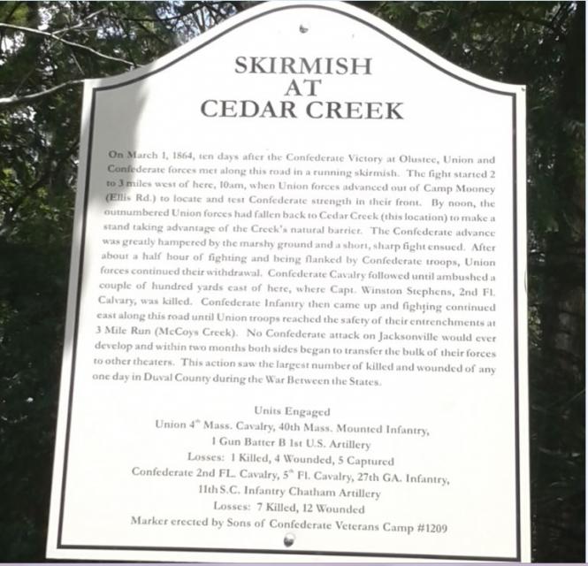
Photo Credits: [1] ROBERT LAND [2] ROBERT LAND
Locationbig map
| UTM (WGS84 Datum) | 17R E 427390 N 3352140 |
|---|---|
| Decimal Degrees | 30.29883333, -81.75510000 |
| Degrees and Decimal Minutes | N 30° 17.93', W 81° 45.306' |
| Degrees, Minutes and Seconds | 30° 17' 55.80" N, 81° 45' 18.36" W |
| Driving Directions | Google Maps |
| Area Code(s) | 904 |
| Closest Postal Address | At or near 6535-6599 Lenox Ave, Jacksonville FL 32205, US |
| Alternative Maps | Google Maps, MapQuest, Bing Maps, Yahoo Maps, MSR Maps, OpenCycleMap, MyTopo Maps, OpenStreetMap |
Is this marker missing? Are the coordinates wrong? Do you have additional information that you would like to share with us? If so, check in.
Nearby Markersshow on map
Show me all markers in: Jacksonville, FL | Duval County | 32205 | Florida | United States of America
Van Zant House
Birth of the Allman Brothers Band
Don Pedro Menendez de Aviles
United States Railroad Administration Locomotive
Centennial Hall Edward Waters College
Old Brewster Hospital
Second Missionary Baptist Church of LaVilla Historical
Historic King's Road British East Florida
The St. Johns
Sinking of the Maple Leaf
Maintenance Issues
- What historical period does the marker represent?
- What historical place does the marker represent?
- What type of marker is it?
- What class is the marker?
- What style is the marker?
- Does the marker have a number?
- What year was the marker erected?
- This marker could use another picture or two.
- Can this marker be seen from the road?
- Is the marker in the median?
Comments 0 comments