Inscription
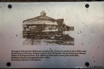
Orange & Alexandria Railroad roundhouse, formerly located near Duke and South Henry Streets. Engine named after Brigadier General Herman Haupt, Chief of Transportation, U.S. Military Railroads during the Civil War. Mathew Brady photograph after 1863. Courtesy Library of Congress.
Details
| HM Number | HM1DMR |
|---|---|
| Additional Information | The tunnel is a heavily used foot and bike trail. Most bikers will ding or verbally state they are behind you to give you time to move. Pavement stays wet a lot through the tunnel, so watch your step. |
| Series | This marker is part of the Orange and Alexandria Railroad series |
| Tags | |
| Historical Period | Civil War, 19th Century |
| Historical Place | Train, Residential Community, Park, Memorial |
| Marker Type | Historic Structure |
| Marker Class | Historical Marker |
| Marker Style | Interpretative Marker / Sign |
| Marker Condition | No reports yet |
| Date Added | Thursday, September 18th, 2014 at 12:28pm PDT -07:00 |
Pictures
Photo Credits: [1] LORA WILSON
Locationbig map
| Directions Information | Located on the western tunnel wall near the Wilkes Street and S. Royal Street intersection. There is a park on the eastern entrance but most parking is on the street. |
|---|---|
| Location Description | Largely a residential area with street parking. Pay attention to street signs to avoid parking tickets. |
| UTM (WGS84 Datum) | 18S E 322457 N 4296573 |
| Decimal Degrees | 38.80005000, -77.04450000 |
| Degrees and Decimal Minutes | N 38° 48.003', W 77° 2.67' |
| Degrees, Minutes and Seconds | 38° 48' 0.1800" N, 77° 2' 40.2000" W |
| Driving Directions | Google Maps |
| Area Code(s) | 202, 703, 571 |
| Can be seen from road? | No |
| Is marker in the median? | No |
| Closest Postal Address | At or near 300-398 Wilkes St, Alexandria VA 22314, US |
| Alternative Maps | Google Maps, MapQuest, Bing Maps, Yahoo Maps, MSR Maps, OpenCycleMap, MyTopo Maps, OpenStreetMap |
Is this marker missing? Are the coordinates wrong? Do you have additional information that you would like to share with us? If so, check in.
Nearby Markersshow on map
Maintenance Issues
- Who or what organization placed the marker?
- This marker could use another picture or two.
- Which side of the road is the marker located?

Comments 0 comments