Inscription
Yamaç Ev 2
— Das Hanghaus 2 —
English: The traces of settlement on the northern slope of Mount Bülbülgo back to the Archaic period (7th/6th century B.C.) when this area was used as a cemetery. During the Hellenıstıc period (ca. 200 B.C.) this slope was articulated with extensive terraces and, in addition to this, a detailed and unstructured development was built.
Terrace House 2 is today defined as a 4,000 m2 insula (a rental house for several parties): over three terraces six separate residential units with separate entrances were originally constructed. Two alleys flanked the insula covering a difference in ground elevation of 27.5 m. The north front of the Terrace House 2 bordered the Curetes Street with a series of tabernae (shops), whereas the 'Terrace House Street" complying with the street grid formed the southern limit.
The residential units built during the early Roman Imperial period (ca. A.D. 20) are characterized by a multi-storeyed peristyle courtyard around which the living space and work areas were assorted. Water supply and drainage occurred thorough shaft wells, and a branched canal system was also provided. While the reception rooms were richly decorated, the domestic work areas such as toilets and kitchens were simply furnished. The lost upper floors, in which rooms for receptions and banquets were located, should be imagined as having been especially luxurious.
Besides numerous small-scale and individual modifications, a total of four or five architectural phases affecting the Terrace House 2 could be identified. Through these reconfigurations, two residential units (3 and 5) were created out of one on the middle terrace; furthermore, a city palace (6) was built at the expense of Residential Unit 4, shrinking its living space.
A series of earthquakes in the 3rd century A.D. put a sudden end to the dwellings in the city centre of Ephesos. The unpredictable natural disaster however resulted in a partly undisturbed inventory of domestic utensils preserved in the earthquake strata.
In the late antique period, at first the ruin was provisionally adapted and used, and only during the 5th century A.D. rebuilding measures can be attested. An extensive reorganization of the area took place, however, only in the 7th century, when an early Byzantine handcraft quarter with mills, smithies and potteries was established over the Roman residential building.
Turkish: Bülbül Dağı'nın kuzey yamacındaki yerleşim izleri, Arkaik Çaǧ'a (İ.Ö. yüzyıl) kadar geri gitmektedir. Ozamanlarda bu alan mezarlık olarak kullanılmıştır. Helenistık Dönem'de (yaklaşık İ.Ö. 200) yamaç, çok sayıdaki teras duvarıyla parçalara bolunmuş, daha sonra ise küçük ünitelerden oluşan, plansız bir yapılaşmaya maruz kalmıştır.
Yamaç Ev 2 günümüzde yaklaşık 4.000 m2'lik büyük bir ada (insula) (pek çok kişiye kiralanan bir ev) olarak tanımlanabilir: Üç teras
uzerinde herbirinin girişi ayrı olan aiti farklı oturma birimi bulunmaktadır. Adanın her iki yanında 27,5 m'lik bir seviye farkını kapatan iki adet sokak bulunur Yamaç Ev 2'nin kuzey cephesi Kuretler Caddesi üzerinde bir sıra taberna (dükkan) ile sınırlanmakla, Efes şehrinin ızgara planına uyan 'Yamaç Ev Caddesi' de güney sınırı oluşturmaktadır.
Erken Roma İmparatorluk Dönemi'nde (İ.S. 20 civarı) inşa edilmiş olan oturma birimleri çok katlı, şıra sütunlarla çevrili (peristil), etrafında oturma ve ev idaresine yönelik çalışma mekanlarının gruplandığı birer merkezi avlu ile karakterize edilmiştir. Su ihtiyacı ve gideri, kuyularla sağlandığı gibi, pek çok kola ayrılan bir kanal sistemi de mevcuttu. Evin resmi kabul salon veya odaları zengin süslemelerle donatılmışken, mutfak ve tuvalet gibi, evin çalışma ve kullanıma yönelik kısımları daha basit bırakılmıştır. Günümüze ulaşmayan, misafir ağırlama ve ziyafet amacıyla kullanılan üst
katların özellikle lüks katlar olduğu düşünülmektedir.
Çok sayıda ufak tefek ve tek tek onarımın Yamaç Ev 2'yi tümden etkileyen toplam dört veya beş iane yapı evresi saptanabilmiştir. Bu yemden şekillendirmelerde orta terastan iki adet oturma birime (3 ve 5) yapılmış, bunun da ötesinde Oturma Birimi 4'un toplam alanını hayli küçülten bir de kent sarayı (6) inşa edilmiştir.
İ.S. 3. yüzyılda ardarda meydana gelen depremler sonucunda Efes'in şehir merkezinde oturmak. imkansız bir hale gelir Bu öngörülemeyen doğal afet sonucunda tahribat tabakalarında evlere ait her tür eşya kısmen de olsa korunagelmiştir.
Geç Anlık Çağ'da kalıntılar acil ihtiyaçlara cevap verecek, şekilde uyarlanarak kullanılmış, ancak İ.S. 5 yüzyıl süresince birtakım mimari önlemler alınmıştır. Alanın tamamiyle yeniden düzenlenmesi ise ancak İ.S 7. yüzyılın başında gerçekleşmiş, Roma Dönemi evlerinin üzerinde değirmenler, nalbantlar ve çömlekçilerin olduğu bir Erken Bizans Danemi zanaatçılar mahallesi kurulmuştur.
German: To read the German text, click on the marker image to enlarge it.
Details
| HM Number | HM1LA5 |
|---|---|
| Tags | |
| Placed By | Kültür ve Turizm Bakanlıǧı and Osterreichisches Archaologisches Institut |
| Marker Condition | No reports yet |
| Date Added | Tuesday, June 23rd, 2015 at 6:01pm PDT -07:00 |
Pictures
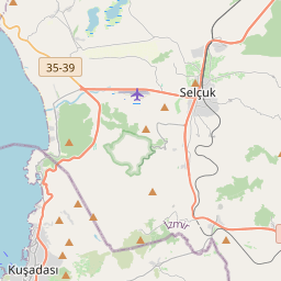
Locationbig map

| UTM (WGS84 Datum) | 35S E 530018 N 4199057 |
|---|---|
| Decimal Degrees | 37.93860000, 27.34161667 |
| Degrees and Decimal Minutes | N 37° 56.316', E 27° 20.497' |
| Degrees, Minutes and Seconds | 37° 56' 18.96" N, 27° 20' 29.82" E |
| Driving Directions | Google Maps |
| Closest Postal Address | At or near Efes Harabeleri, İzmir 35920, TR |
| Alternative Maps | Google Maps, MapQuest, Bing Maps, Yahoo Maps, MSR Maps, OpenCycleMap, MyTopo Maps, OpenStreetMap |
Is this marker missing? Are the coordinates wrong? Do you have additional information that you would like to share with us? If so, check in.
Nearby Markersshow on map
Maintenance Issues
- Is this marker part of a series?
- What historical period does the marker represent?
- What historical place does the marker represent?
- What type of marker is it?
- What class is the marker?
- What style is the marker?
- Does the marker have a number?
- What year was the marker erected?
- This marker needs at least one picture.
- Can this marker be seen from the road?
- Is the marker in the median?
Comments 0 comments