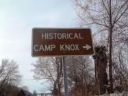
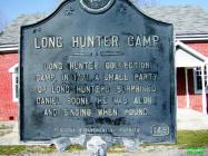
They entered into what is now Green County in 1770. They made their Base Camp (Camp Knox), in a valley they called the Beech Woods. Today, the Mt. Gilead Christian Church stands on the historic Camp Knox site. This camp served as their headquarters for frequent hunting excursions throughout a large area surrounding this camp. They brought back to their base camp the skins of deer, buffalo, elk, bear, beaver, and smaller animals. Over a period of several months, they had accumulated an enormous number of skins. They constructed a crude structure they called a "skinhouse" to protect their pelts from the weather. They named the small branch of water that flowed beside their campsite, "Skinhouse Branch."
The Long Hunters were forced to leave their campsite and return to their homes due to Indian raids. They were also forced to leave most of their valuable hides at the camp.
Returning to Camp Knox several years later, they found that many of the hides had been stolen by Indians, and the remaining skins had rotted due to being exposed to the weather. On a nearby tree, one Long Hunter carved, "2300 lost - ruination by God."
Many of these original Long Hunters later returned to this area and settled with their families: Skaggs, Graham, Miller, Workman, Lisle, Hancock, Haskins, Caldwell, Allen, and Montgomery.
The Long Hunters' Camp Knox Historic Site is located in Southern Green County near the Adair County line near Highway Route 61. A monument dedicated to the Long Hunters is located in front of Mt. Gilead Church that describes the historic Camp Knox to visitors.
| HM Number | HM1QDC |
|---|---|
| Tags | |
| Historical Period | 18th Century |
| Historical Place | Church/House of Worship |
| Marker Type | Historic Structure |
| Marker Class | Historical Marker |
| Marker Style | Mounted |
| Marker Number | 148 |
| Placed By | Ky Dept. Of Highways |
| Marker Condition |           9 out of 10 (2 reports) |
| Date Added | Monday, January 4th, 2016 at 5:02pm PST -08:00 |
| Directions Information | Highway 61 to highway 767. See the Long Hunter sign, turn right, going from Columbia, KY. |
|---|---|
| UTM (WGS84 Datum) | 16S E 643641 N 4115135 |
| Decimal Degrees | 37.17161300, -85.38203500 |
| Degrees and Decimal Minutes | N 37° 10.2968', W 85° 22.9221' |
| Degrees, Minutes and Seconds | 37° 10' 17.8068" N, 85° 22' 55.3260" W |
| Driving Directions | Google Maps |
| Area Code(s) | 270 |
| Can be seen from road? | Yes |
| Is marker in the median? | No |
| Closest Postal Address | At or near 2-500 Buford Dial, Greensburg KY 42743, US |
| Alternative Maps | Google Maps, MapQuest, Bing Maps, Yahoo Maps, MSR Maps, OpenCycleMap, MyTopo Maps, OpenStreetMap |
Is this marker missing? Are the coordinates wrong? Do you have additional information that you would like to share with us? If so, check in.
I Saw The Marker
I am the blessed minister of this wonderful congregation and am equally blessed to have a historic site such as Camp Knox as our meeting place. The markers are still in excellent shape and all are welcome to come and see them anytime.
Sep 5, 2019 at 9:54am PDT by brorob
- Is this marker part of a series?
- Which side of the road is the marker located?


Comments 0 comments