Inscription
Opened: October 1, 1958
This site was originally settled in 1649 and was known as the Westminster parish. About 1780 it was the property of Francis Cromwell, a cousin of the monarch of England. It was obtained by the Curtis Creek Mining Co. in 1850 from the estate of John Glenn. In 1908, the state used the site as a rifle range and an army camp was set up here during World War I.Details
| HM Number | HM96Y |
|---|---|
| Tags | |
| Year Placed | 1958 |
| Placed By | Community Research and Development, Inc |
| Marker Condition |  9 out of 10 (1 reports) |
| Date Added | Monday, September 29th, 2014 at 10:41pm PDT -07:00 |
Pictures
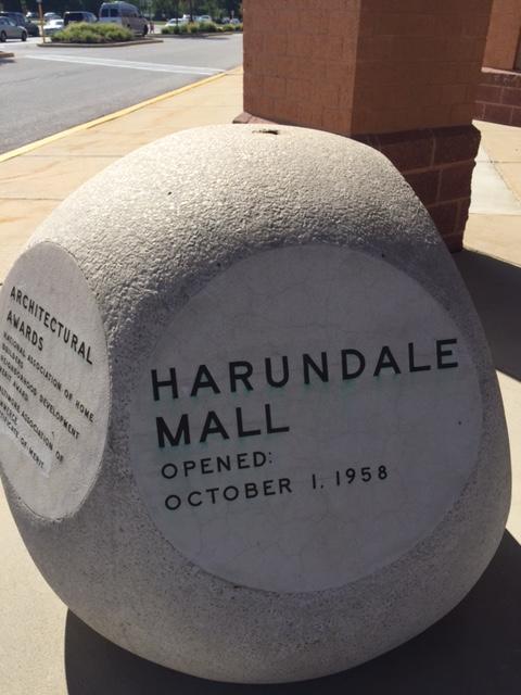
Photo Credits: [1] LISA NAPIER
Locationbig map
| UTM (WGS84 Datum) | 18S E 360394 N 4334839 |
|---|---|
| Decimal Degrees | 39.15156667, -76.61563333 |
| Degrees and Decimal Minutes | N 39° 9.094', W 76° 36.938' |
| Degrees, Minutes and Seconds | 39° 9' 5.64" N, 76° 36' 56.28" W |
| Driving Directions | Google Maps |
| Area Code(s) | 410, 443, 301 |
| Closest Postal Address | At or near 7714 Ritchie Hwy, Glen Burnie MD 21061, US |
| Alternative Maps | Google Maps, MapQuest, Bing Maps, Yahoo Maps, MSR Maps, OpenCycleMap, MyTopo Maps, OpenStreetMap |
Is this marker missing? Are the coordinates wrong? Do you have additional information that you would like to share with us? If so, check in.
Nearby Markersshow on map
I Saw The Marker
Saw it at the old Harundale site. I have a pic of myself sitting in it when I was four , forty years ago. It was moved when the mall was demolished.
Aug 16, 2015 at 12:43pm PDT by chaplinssmile
Maintenance Issues
- Is this marker part of a series?
- What historical period does the marker represent?
- What historical place does the marker represent?
- What type of marker is it?
- What class is the marker?
- What style is the marker?
- Does the marker have a number?
- This marker could use another picture or two.
- Can this marker be seen from the road?
- Is the marker in the median?
Comments 0 comments