Inscription
The Memory Of
Major
A. Frederick Oberlin
An Eminent Soldier
And Citizen
This Bridge Which Was Erected
Under His Supervision, Is Dedicated
By The Town of Hamden As
The
" A. Frederick Oberlin
Bridge"
Details
| HM Number | HMJ50 |
|---|---|
| Tags | |
| Historical Period | WW I |
| Historical Place | Bridge |
| Marker Type | Historic Structure |
| Marker Class | Historical Marker |
| Marker Style | Commemmorative Marker |
| Placed By | Town of Hamden |
| Marker Condition |  9 out of 10 (1 reports) |
| Date Added | Thursday, October 16th, 2014 at 4:30am PDT -07:00 |
Pictures
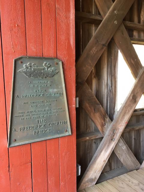

Photo Credits: [1] JODY LEADER [2] JODY LEADER
Locationbig map
| Directions Information | Marker is in the covered bridge at the edge of East Rock Park. |
|---|---|
| UTM (WGS84 Datum) | 18T E 674836 N 4578163 |
| Decimal Degrees | 41.33600000, -72.91053333 |
| Degrees and Decimal Minutes | N 41° 20.16', W 72° 54.632' |
| Degrees, Minutes and Seconds | 41° 20' 9.6000" N, 72° 54' 37.9200" W |
| Driving Directions | Google Maps |
| Area Code(s) | 203 |
| Can be seen from road? | No |
| Is marker in the median? | No |
| Closest Postal Address | At or near 416 Black Trail, Hamden CT 06517, US |
| Alternative Maps | Google Maps, MapQuest, Bing Maps, Yahoo Maps, MSR Maps, OpenCycleMap, MyTopo Maps, OpenStreetMap |
Is this marker missing? Are the coordinates wrong? Do you have additional information that you would like to share with us? If so, check in.
Nearby Markersshow on map
I Saw The Marker
Marker in good condition. No indication on marker of date of marker or date that the bridge was constructed.
May 2, 2018 at 7:45pm PDT by jodyleader1
Maintenance Issues
- Is this marker part of a series?
- This marker could use another picture or two.
- Which side of the road is the marker located?
Comments 0 comments