Inscription
Originally an open courtyard, Bastion A was roofed over, probably in the 1870's to accommodate new artillery-15-inch Rodman Guns. The new space was divided into an indoor drill hall, a powder magazine and a storage area for wagons and gun carriages. Construction was carefully routed around a well (now blocked off). During the Second World War the area became a fort favorite: a recreation hall where soldiers on a cold, isolated post could take their minds off training and war. Today the "Dark Arch" leads to a murky passageway to the exterior of the fort.
Details
| HM Number | HM147L |
|---|---|
| Tags | |
| Marker Condition | No reports yet |
| Date Added | Saturday, September 20th, 2014 at 3:18pm PDT -07:00 |
Pictures
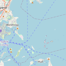
Locationbig map


| UTM (WGS84 Datum) | 19T E 341247 N 4687083 |
|---|---|
| Decimal Degrees | 42.31981667, -70.92653333 |
| Degrees and Decimal Minutes | N 42° 19.189', W 70° 55.592' |
| Degrees, Minutes and Seconds | 42° 19' 11.34" N, 70° 55' 35.52" W |
| Driving Directions | Google Maps |
| Area Code(s) | 781 |
| Closest Postal Address | At or near 1499 Unnamed Road, Hull MA 02045, US |
| Alternative Maps | Google Maps, MapQuest, Bing Maps, Yahoo Maps, MSR Maps, OpenCycleMap, MyTopo Maps, OpenStreetMap |
Is this marker missing? Are the coordinates wrong? Do you have additional information that you would like to share with us? If so, check in.
Nearby Markersshow on map
Maintenance Issues
- Is this marker part of a series?
- What historical period does the marker represent?
- What historical place does the marker represent?
- What type of marker is it?
- What class is the marker?
- What style is the marker?
- Does the marker have a number?
- What year was the marker erected?
- Who or what organization placed the marker?
- This marker needs at least one picture.
- Can this marker be seen from the road?
- Is the marker in the median?
Comments 0 comments