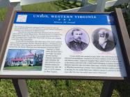
History All Around
The Confederate Monument, dedicated in 1901 to honor the local men who served the South, is up the walkway to your left. Thirteen Confederate companies were formed here in Monroe County.From the top of the hill, behind the monument and the tree line half a mile away stands Walnut Grove. This house served as a hospital when Federal forces under Gen. George Crook occupied Union for five days in 1864. Incomplete pairs of shoes later found under the house were allegedly tossed there after amputations.
To your left are the Knobs, hills where many of the town's residents hid as Crook approached. The Rev. Samuel R. Houston, a Presbyterian minister who kept a diary during the war, lived in the brick house behind, across from the church. Elmwood, the brick mansion of attorney Allen T. Caperton, is visible above the stone wall to your right. As county provost marshal, Caperton imprisoned loyal Unionists. He also served as a Confederate senator for Virginia and, after the war, as a U.S. senator for West Virginia.
Crook's 10,000 men camped in these fields. Like other houses here, Elmwood was plundered, "entered by 50 {Union soldiers} at the front door and almost ruined." Caperton's daughter Mary asked Crook to return a cow so her family could have milk. A gold medal belonging to another daughter, Melinda Caperton, also was taken. Years later, a former Confederate officer in Wheeling learned that a former Union soldier had just traded a canteen of whiskey for the medal. Both men wished to return it, and thirty-three years after the war, the medal came back to Elmwood
| HM Number | HM1498 |
|---|---|
| Series | This marker is part of the West Virginia Civil War Trails series |
| Tags | |
| Placed By | West Virginia Civil War Trails |
| Marker Condition |           6 out of 10 (1 reports) |
| Date Added | Tuesday, September 16th, 2014 at 6:36am PDT -07:00 |
| UTM (WGS84 Datum) | 17S E 540298 N 4161100 |
|---|---|
| Decimal Degrees | 37.59610000, -80.54350000 |
| Degrees and Decimal Minutes | N 37° 35.766', W 80° 32.61' |
| Degrees, Minutes and Seconds | 37° 35' 45.96" N, 80° 32' 36.60" W |
| Driving Directions | Google Maps |
| Area Code(s) | 304 |
| Closest Postal Address | At or near 2 5th St, Union WV 24983, US |
| Alternative Maps | Google Maps, MapQuest, Bing Maps, Yahoo Maps, MSR Maps, OpenCycleMap, MyTopo Maps, OpenStreetMap |
Is this marker missing? Are the coordinates wrong? Do you have additional information that you would like to share with us? If so, check in.
Something Else
I have photo of this marker, not sure how to upload. And not sure of the text that has been typed for this.
Feb 25, 2016 at 9:00am PST by sabrinaoj173
- What historical period does the marker represent?
- What historical place does the marker represent?
- What type of marker is it?
- What class is the marker?
- What style is the marker?
- Does the marker have a number?
- What year was the marker erected?
- This marker could use another picture or two.
- Can this marker be seen from the road?
- Is the marker in the median?

Comments 0 comments