Inscription
Frankfort takes its name-many people believe-from an episode that took place near here during the frontier era. A group of explorers camping near the mouth of Benson Creek was attacked by Indians. One member of the group, Stephen Frank, was killed. After that, people began to refer to the Kentucky River crossing point here as Franks Ford. Over time, this changed to Frankfort. Another theory holds that the town was named after Frankfurt, Germany. When settlers first established Frankfort in the 1780s, there was a sizeable island in the Kentucky River near the mouth of Benson Creek. It became known as Fishtrap Islands Native Americans took advantage of the narrow passages on either side of the island. They extended nets across these channels and trapped fish in them. Frankfort's early settlers did the same thing and enjoyed an abundant catch of fish from the Kentucky River for many years. All of this came to an end when Lock and Dam Number 4 were built just downstream from here. The dam raised the water level so much that Fishtrap Island was permanently inundated and disappeared. The mouth of Benson Creek, across the Kentucky River from here, marks the point where Kentuckys first three counties came together. You are standing in what was Fayette County. To your left front was Lincoln County, and to your right front was Jefferson County.
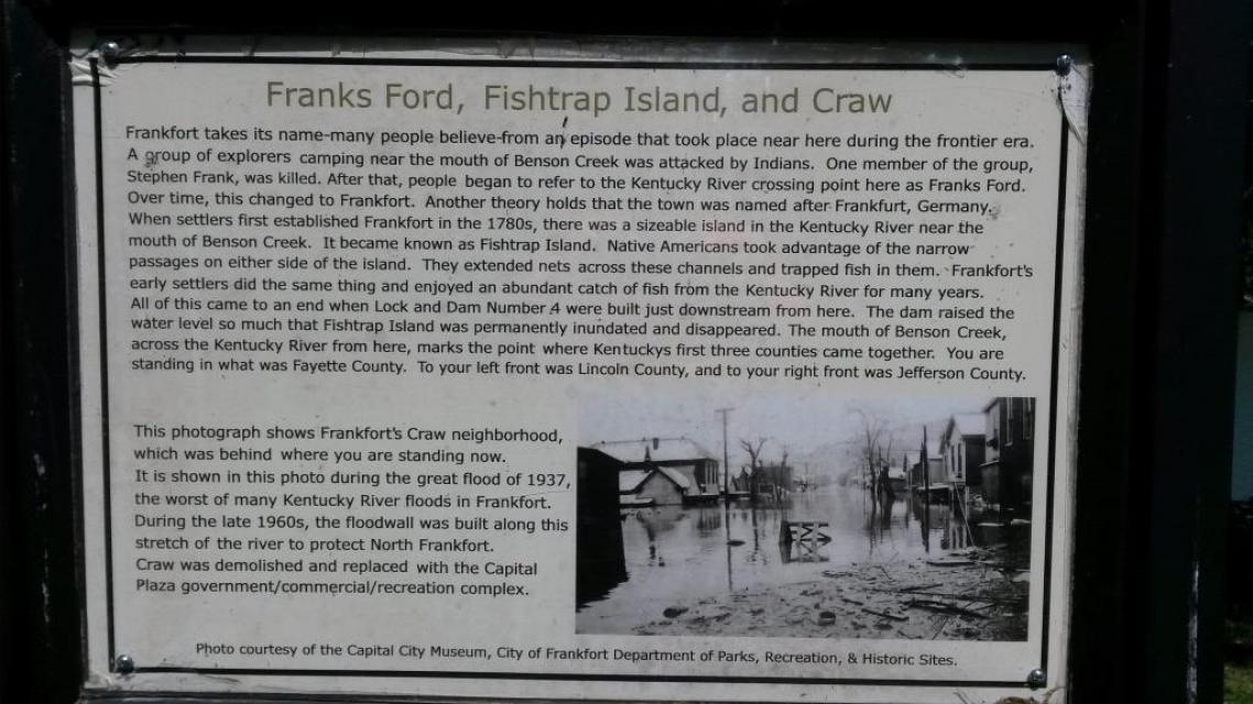
This photograph shows Frankfort's Craw neighborhood, which was behind where you are standing now. It is shown in this photo during the great flood of 1937, the worst of many Kentucky River floods in Frankfort. During the late 1960s, the floodwall was built along this stretch of the river to protect North Frankfort. Craw was demolished and replaced with the Capital Plaza government/commercial/recreation complex.
Photo courtesy of the Capital City Museum, City of Frankfort Department of Parks, Recreation, & Historic Sites.
Details
| HM Number | HM16AO |
|---|---|
| Tags | |
| Marker Condition |  7 out of 10 (1 reports) |
| Date Added | Tuesday, September 23rd, 2014 at 10:30am PDT -07:00 |
Pictures
Locationbig map
| UTM (WGS84 Datum) | 16S E 685621 N 4230472 |
|---|---|
| Decimal Degrees | 38.20308333, -84.88005000 |
| Degrees and Decimal Minutes | N 38° 12.185', W 84° 52.803' |
| Degrees, Minutes and Seconds | 38° 12' 11.10" N, 84° 52' 48.18" W |
| Driving Directions | Google Maps |
| Area Code(s) | 502 |
| Closest Postal Address | At or near 201 Riverview Trail, Frankfort KY 40601, US |
| Alternative Maps | Google Maps, MapQuest, Bing Maps, Yahoo Maps, MSR Maps, OpenCycleMap, MyTopo Maps, OpenStreetMap |
Is this marker missing? Are the coordinates wrong? Do you have additional information that you would like to share with us? If so, check in.
Nearby Markersshow on map
Show me all markers in: Frankfort, KY | Franklin County | 40601 | Kentucky | United States of America
Maintenance Issues
- Is this marker part of a series?
- What historical period does the marker represent?
- What historical place does the marker represent?
- What type of marker is it?
- What class is the marker?
- What style is the marker?
- Does the marker have a number?
- What year was the marker erected?
- Who or what organization placed the marker?
- This marker could use another picture or two.
- Can this marker be seen from the road?
- Is the marker in the median?
Comments 0 comments