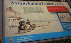
Inscription
Star-Spangled Banner National Historic Trail
The taverns and the ferry made Havre de Grace, originally called Susquehanna Lower Ferry, a successful town in the early 19th century. People arrived via the Post Road, the major route of north/south travel in the day, and crossed the Susquehanna River on one of the ferries."By several passengers in the stage, which arrived last evening, information is received that about the dawn of day yesterday morning, a considerable number of the enemy came up as high as Havre-de-Grace and commenced the bombardment of that place with shot, shells and rockets."
Baltimore Patriot, May 4, 1813
Taverns provided food, drink, and lodging for travelers as they waited for river conditions to allow passage. Mrs. Sears' Tavern stood near this location and Mr. Mansfield's Tavern was just north. News traveled into town with the passengers on the Post Road, and locals would frequent the taverns to hear the latest happenings in Baltimore and Philadelphia.
Details
| HM Number | HM17KI |
|---|---|
| Series | This marker is part of the Star Spangled Banner National Historic Trail series |
| Tags | |
| Historical Period | 19th Century |
| Historical Place | Business Center, River |
| Marker Type | Historic District |
| Marker Class | Historical Marker |
| Marker Style | Free Standing |
| Placed By | National Park Service, U.S. Department of the Interior |
| Marker Condition | No reports yet |
| Date Added | Tuesday, October 21st, 2014 at 12:04am PDT -07:00 |
Pictures
Locationbig map
| UTM (WGS84 Datum) | 18S E 406270 N 4378655 |
|---|---|
| Decimal Degrees | 39.55246667, -76.09095000 |
| Degrees and Decimal Minutes | N 39° 33.148', W 76° 5.457' |
| Degrees, Minutes and Seconds | 39° 33' 8.8800" N, 76° 5' 27.4200" W |
| Driving Directions | Google Maps |
| Area Code(s) | 443, 410 |
| Can be seen from road? | No |
| Is marker in the median? | No |
| Closest Postal Address | At or near 501 St John St, Havre de Grace MD 21078, US |
| Alternative Maps | Google Maps, MapQuest, Bing Maps, Yahoo Maps, MSR Maps, OpenCycleMap, MyTopo Maps, OpenStreetMap |
Is this marker missing? Are the coordinates wrong? Do you have additional information that you would like to share with us? If so, check in.
Nearby Markersshow on map
Show me all markers in: Havre de Grace, MD | Harford County | 21078 | Maryland | United States of America
Maintenance Issues
- Which side of the road is the marker located?


Comments 0 comments