Inscription
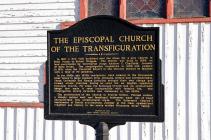
In 1867 a New York architect sent the plans for a new church in Belle Plaine to Bishop Whipple. The church was built in 1868 on land contributed by Territorial Judge Andrew G. Chatfield, founder of Belle Plaine. The congregation organized in 1858 and peaked in 1871, when the Parochial Report to the Diocese showed 16 families with a total of 70 members.
In the 1860s and 1870s immigrants were coming to the Minnesota River Valley in large numbers from Germany, Ireland and Czechoslovakia. These Lutherans and Roman Catholics brought their own clergy and formed ethnic churches having no need for an English - speaking Episcopal Church. For some, the Episcopal Church had an aristocratic image that made it seem incompatible with frontier life. The congregation slowly dwindled and disbanded in the 1950s.
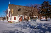
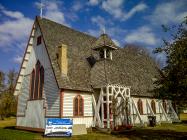
The architecture of the church is Prairie Gothic. Pointed arches, a steeply gabled roof, and functional buttresses made out of wood characterized this architectural style. The Episcopal Church's employment of Gothic architecture, popular at the time, symbolized tradition and history in the newly settled Minnesota River Valley.
Erected in 1999
Scott County Historical Society
In the 1860s and 1870s immigrants were coming to the Minnesota River Valley in large numbers from Germany, Ireland and Czechoslovakia. These Lutherans and Roman Catholics brought their own clergy and formed ethnic churches having no need for an English - speaking Episcopal Church. For some, the Episcopal Church had an aristocratic image that made it seem incompatible with frontier life. The congregation slowly dwindled and disbanded in the 1950s.
The architecture of the church is Prairie Gothic. Pointed arches, a steeply gabled roof, and functional buttresses made out of wood characterized this architectural style. The Episcopal Church's employment of Gothic architecture, popular at the time, symbolized tradition and history in the newly settled Minnesota River Valley.
Scott County Historical Society
Details
| HM Number | HM18SD |
|---|---|
| Additional Information | This church was added to National Register of Historic Places on April 17, 1980, NRHP Reference#: 80002159 |
| Series | This marker is part of the Minnesota: Scott County Historical Society series |
| Tags | |
| Historical Period | 19th Century, 20th Century |
| Historical Place | Church/House of Worship, National Register of Historic Places |
| Marker Type | Historic Building |
| Marker Class | Historical Marker |
| Marker Style | Free Standing |
| Year Placed | 1999 |
| Placed By | The Scott County Historical Society |
| Marker Condition | No reports yet |
| Date Added | Friday, September 26th, 2014 at 5:50pm PDT -07:00 |
Pictures
Photo Credits: [1] MARTHA DECKER [2] MARTHA DECKER [3] MARTHA DECKER [4] MARTHA DECKER
Locationbig map
| UTM (WGS84 Datum) | 15T E 439426 N 4941527 |
|---|---|
| Decimal Degrees | 44.62455000, -93.76358333 |
| Degrees and Decimal Minutes | N 44° 37.473', W 93° 45.815' |
| Degrees, Minutes and Seconds | 44° 37' 28.3800" N, 93° 45' 48.9000" W |
| Driving Directions | Google Maps |
| Area Code(s) | 952, 507 |
| Can be seen from road? | Yes |
| Is marker in the median? | No |
| Which side of the road? | Marker is on the right when traveling North |
| Closest Postal Address | At or near 201-299 Co Hwy 6, Belle Plaine MN 56011, US |
| Alternative Maps | Google Maps, MapQuest, Bing Maps, Yahoo Maps, MSR Maps, OpenCycleMap, MyTopo Maps, OpenStreetMap |
Is this marker missing? Are the coordinates wrong? Do you have additional information that you would like to share with us? If so, check in.
Nearby Markersshow on map
Show me all markers in: Belle Plaine, MN | Scott County | 56011 | Minnesota | United States of America


Comments 0 comments