Inscription
Great Smoky Mountains National Park
The high, rounded mountain in front of you is Clingmans Dome (6,643 feet elevation), the highest mountain in Great Smoky Mountains National Park, the highest in Tennessee, and the third highest in the eastern United States. It bears the name of Thomas Lanier Clingman, explorer, politician, promoter, and Civil War general, who measured mountains here in the mid-1800s.Clingman, and scientists Arnold Guyot, Samuel Buckley, and John Le Conte, measured mountains using barometers considered crude by today's standards. They used the instruments to measure atmospheric pressure at the mountain summits. Later they would compare the measurement to pressure readings taken by colleagues at the exact same point in time from known lowland elevations.
Using complicated mathematical formulas, considering air temperature, humidity, latitude, and other variables, the scientists calculated a mountain's elevation. As you explore the park you might notice that the highest peaks bear these names—Clingmans Dome (6,643 feet), Mount Guyot (6,621 feet), and Mount Le Conte (6,593 feet).
Charles A. Webb
This overlook is named for Charles A. Webb, editor of the Asheville Citizen-Times in the early 1930s. Webb's strong and influential voice helped lead the fight to establish Great Smoky Mountains National Park.
Top Six Eastern Peaks
All located in North Carolina and Tennessee
· Mt. Mitchell—6,684 feet (2037 m)
· Mt. Craig—6,647 ft (2026 m)
· Clingmans Dome*—6,643 ft (2025 m)
· Mt. Guyot*—6,621 ft (2018 m)
· Balsam Cone—6,611 ft (2015 m)
· Mt. Le Conte*—6,593 ft (2010 m)
(New Hampshire's Mt. Washington, at 6,288 feet (1917 m), is the 17th highest peak in the East)
Details
| HM Number | HM1A9D |
|---|---|
| Tags | |
| Placed By | National Park Service |
| Marker Condition | No reports yet |
| Date Added | Tuesday, October 7th, 2014 at 9:37am PDT -07:00 |
Pictures
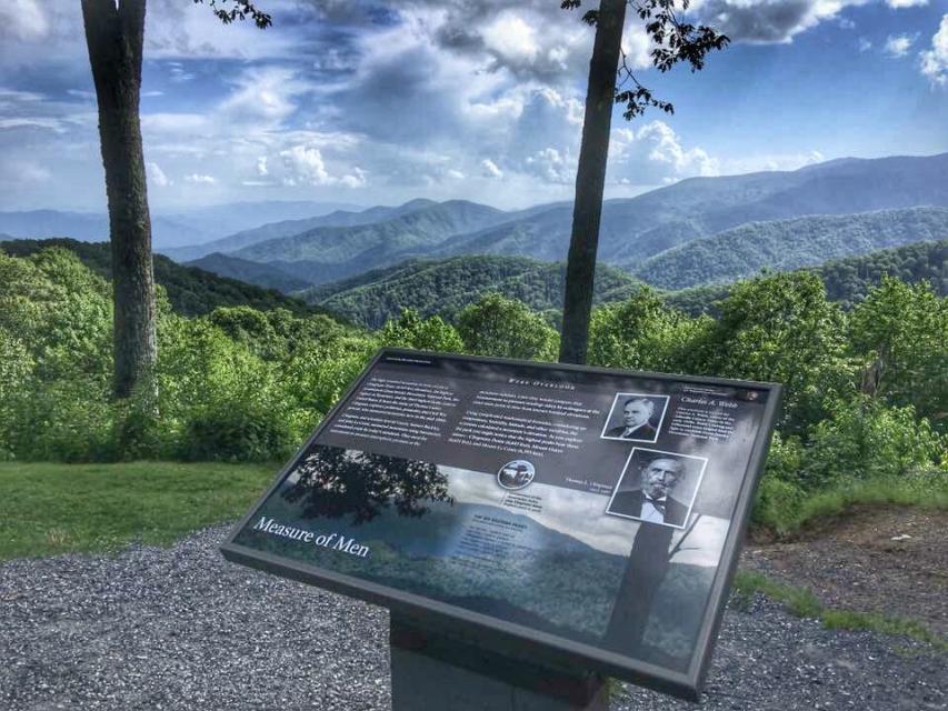
Photo Credits: [1] ROADRUNNERSUSA
Locationbig map
| UTM (WGS84 Datum) | 17S E 282057 N 3940944 |
|---|---|
| Decimal Degrees | 35.58825000, -83.40548333 |
| Degrees and Decimal Minutes | N 35° 35.295', W 83° 24.329' |
| Degrees, Minutes and Seconds | 35° 35' 17.70" N, 83° 24' 19.74" W |
| Driving Directions | Google Maps |
| Area Code(s) | 828 |
| Closest Postal Address | At or near 1079L Unnamed Road, Bryson City NC 28713, US |
| Alternative Maps | Google Maps, MapQuest, Bing Maps, Yahoo Maps, MSR Maps, OpenCycleMap, MyTopo Maps, OpenStreetMap |
Is this marker missing? Are the coordinates wrong? Do you have additional information that you would like to share with us? If so, check in.
Nearby Markersshow on map
Show me all markers in: Bryson City, NC | Swain County | 28713 | North Carolina | United States of America
Maintenance Issues
- Is this marker part of a series?
- What historical period does the marker represent?
- What historical place does the marker represent?
- What type of marker is it?
- What class is the marker?
- What style is the marker?
- Does the marker have a number?
- What year was the marker erected?
- This marker could use another picture or two.
- Can this marker be seen from the road?
- Is the marker in the median?
Comments 0 comments