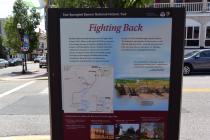
Inscription
Star-Spangled Banner National Historic Trail
British raiders traveled along rivers to Upper Bay towns in 1813. Elkton, at the head of Elk River, expected to be a target, because it could be a landing site for an advance on Philadelphia. Citizens of Elkton built three earthen forts and placed a chain across the river for defense. On April 29 they fended off a British assault. Focusing on easier targets, the British then struck Frenchtown, Havre de Grace, Fredericktown, Georgetown and Queenstown in quick succession.On July 12, 1814, the British again attacked Elkton. The defenders "gave them in all eleven guns, so well directed, that they hastily...retreated down the river..." Only one other place in Maryland —St. Michaels—succeeded twice in repulsing British attacks.
"Two small batteries...in the town...opened their fire upon the barges, and...compelled them to retreat with considerable precipitation..."
Report on Elkton Skirmish in Alexandria Gazette, August 18, 1813
Nearby places to explore the War of 1812 in the Upper Bay:
Charlestown - Yielded to the British to avoid destruction of the town; period buildings
Lower Susquehanna Scenic Byway - 33-mile driving route from Havre de Grace to Perryville
Historic Elk Landing - Site of Fort Hollingsworth, a defensive earthwork that protected Elkton
Havre de Grace - Several sites that survived a British raid
Mount Harmon Plantation - 18th-century residence and tobacco prize house; Education and Discovery Center
Drawing
Fort Hollingsworth was one of the earthwork forts that successfully defended Elkton form two British attacks.
Details
| HM Number | HM1EHO |
|---|---|
| Tags | |
| Marker Condition | No reports yet |
| Date Added | Tuesday, October 14th, 2014 at 5:47pm PDT -07:00 |
Pictures
Photo Credits: [1] BRIDGER1963
Locationbig map
| UTM (WGS84 Datum) | 18S E 428773 N 4384562 |
|---|---|
| Decimal Degrees | 39.60785000, -75.82970000 |
| Degrees and Decimal Minutes | N 39° 36.471', W 75° 49.782' |
| Degrees, Minutes and Seconds | 39° 36' 28.26" N, 75° 49' 46.92" W |
| Driving Directions | Google Maps |
| Area Code(s) | 443, 410 |
| Closest Postal Address | At or near 101-103 E Main St, Elkton MD 21921, US |
| Alternative Maps | Google Maps, MapQuest, Bing Maps, Yahoo Maps, MSR Maps, OpenCycleMap, MyTopo Maps, OpenStreetMap |
Is this marker missing? Are the coordinates wrong? Do you have additional information that you would like to share with us? If so, check in.
Nearby Markersshow on map
Maintenance Issues
- Is this marker part of a series?
- What historical period does the marker represent?
- What historical place does the marker represent?
- What type of marker is it?
- What class is the marker?
- What style is the marker?
- Does the marker have a number?
- What year was the marker erected?
- Who or what organization placed the marker?
- This marker could use another picture or two.
- Can this marker be seen from the road?
- Is the marker in the median?

Comments 0 comments