Inscription
Star-Spangled Banner National Historic Trail
— War of 1812 —
As the British savagely burned the buildings in Havre de Grace during their morning attack May 3, 1813, the townspeople ran west for protection to a home that stood near this location. The home, known as Bloomsbury, was owned by Baltimore businessman Mark Pringle. His warehouses of flour, which lay close to the water's edge, were lost; however, the British spared the home.
(Inscription next to the image of the Pringle Mansion) Pringle Mansion known as Bloomsbury, was located on land that is now part of the railroad right-of-way. Illustration by Benson J. Lossing, Field Book of the War of 1812, 1868.
Details
| HM Number | HM1IW1 |
|---|---|
| Series | This marker is part of the Star Spangled Banner National Historic Trail series |
| Tags | |
| Placed By | National Park Service-United States Department of the Interior |
| Marker Condition | No reports yet |
| Date Added | Monday, January 19th, 2015 at 1:06pm PST -08:00 |
Pictures
Locationbig map

| UTM (WGS84 Datum) | 18S E 405156 N 4377818 |
|---|---|
| Decimal Degrees | 39.54480000, -76.10380000 |
| Degrees and Decimal Minutes | N 39° 32.688', W 76° 6.228' |
| Degrees, Minutes and Seconds | 39° 32' 41.28" N, 76° 6' 13.68" W |
| Driving Directions | Google Maps |
| Area Code(s) | 443, 410 |
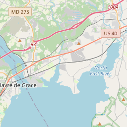
| Closest Postal Address | At or near 351 Lewis Ln, Havre de Grace MD 21078, US |
| Alternative Maps | Google Maps, MapQuest, Bing Maps, Yahoo Maps, MSR Maps, OpenCycleMap, MyTopo Maps, OpenStreetMap |
Is this marker missing? Are the coordinates wrong? Do you have additional information that you would like to share with us? If so, check in.
Nearby Markersshow on map
Show me all markers in: Havre de Grace, MD | Harford County | 21078 | Maryland | United States of America
Maintenance Issues
- What historical period does the marker represent?
- What historical place does the marker represent?
- What type of marker is it?
- What class is the marker?
- What style is the marker?
- Does the marker have a number?
- What year was the marker erected?
- This marker needs at least one picture.
- Can this marker be seen from the road?
- Is the marker in the median?
Comments 0 comments