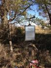
This marker is placed here in their memory.
1st Lt. Melvin S. Meeker, Pilot
2nd Lt. Samuel Levitt, Copilot
2nd Lt. Mathew J. Radosvich, Bombardier
T/Sgt. James M. Parker, Engineer
T/Sgt. Thomas J. Leyshon, Radioman
The crew was on a navigation training flight from Topka Army Air Force Base, Topeka, Kansas to Duluth, Minnesota, at the time of the crash.
| HM Number | HM1IYE |
|---|---|
| Additional Information | Walk up to the edge of the fence and look onto the property and you will see three indentations in the ground. One large one with two small ones on each side. This is the original impact craters. The land owner left them there as part of the memorial. |
| Series | This marker is part of the WWII Army Air Corp Aircraft Crashes series |
| Tags | |
| Historical Period | 20th Century |
| Historical Place | Memorial |
| Marker Type | Memorial |
| Marker Class | Both |
| Marker Style | Free Standing |
| Placed By | Landowner |
| Marker Condition |           4 out of 10 (1 reports) |
| Date Added | Tuesday, January 27th, 2015 at 5:39pm PST -08:00 |
| Directions Information | Use Google Maps or Apple Maps to get directions to 1792 K Ave, Ogden, IA |
|---|---|
| Location Description | Center of marker below the air plane atop the marker |
| UTM (WGS84 Datum) | 15T E 419634 N 4644879 |
| Decimal Degrees | 41.95180200, -93.96965200 |
| Degrees and Decimal Minutes | N 41° 57.1081', W 93° 58.1791' |
| Degrees, Minutes and Seconds | 41° 57' 6.4872" N, 93° 58' 10.7472" W |
| Driving Directions | Google Maps |
| Area Code(s) | 515 |
| Can be seen from road? | Yes |
| Is marker in the median? | No |
| Which side of the road? | Marker is on the right when traveling North |
| Closest Postal Address | At or near 1700-1798 K Ave, Boone IA 50036, US |
| Alternative Maps | Google Maps, MapQuest, Bing Maps, Yahoo Maps, MSR Maps, OpenCycleMap, MyTopo Maps, OpenStreetMap |
Is this marker missing? Are the coordinates wrong? Do you have additional information that you would like to share with us? If so, check in.
I Saw The Marker
The marker seems to be fairly weathered. The farmstead / property appears to have been demolished and area converted into tilled agricultural land. The mentioned impact craters were not apparent since the crash site was planted with corn. Since the area appears to have been bulldozed, it would be questionable if the impact craters are still there.
Aug 16, 2016 at 12:34pm PDT by mjfdonovan
- This marker could use another picture or two.

Comments 0 comments