Inscription
For Col. William Christian, native Virginian, soldier, politician, and pioneer. Served as Colonel in Revolution, member Va. Legislature. Moved family to Jefferson County in 1785, where his Va. land grants totaled 9,000 acres. Killed 1786, defending frontier against Indians. Original county, taken from Logan, included area of 16 present-day counties and parts of 4 others.
Details
| HM Number | HM1O4L |
|---|---|
| Tags | |
| Marker Number | 1224 |
| Year Placed | 1969 |
| Placed By | The Kentucky Historical Society Kentucky Department of Highways |
| Marker Condition | No reports yet |
| Date Added | Wednesday, September 23rd, 2015 at 1:02pm PDT -07:00 |
Pictures
Locationbig map


| UTM (WGS84 Datum) | 16S E 456492 N 4080231 |
|---|---|
| Decimal Degrees | 36.86701667, -87.48813333 |
| Degrees and Decimal Minutes | N 36° 52.021', W 87° 29.288' |
| Degrees, Minutes and Seconds | 36° 52' 1.26" N, 87° 29' 17.28" W |
| Driving Directions | Google Maps |
| Area Code(s) | 270 |
| Which side of the road? | Marker is on the right when traveling South |
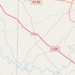
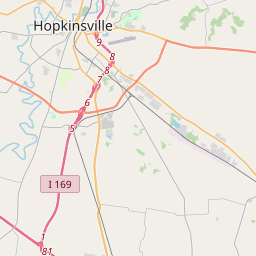
| Closest Postal Address | At or near 100-160 Court St, Hopkinsville KY 42240, US |
| Alternative Maps | Google Maps, MapQuest, Bing Maps, Yahoo Maps, MSR Maps, OpenCycleMap, MyTopo Maps, OpenStreetMap |
Is this marker missing? Are the coordinates wrong? Do you have additional information that you would like to share with us? If so, check in.
Nearby Markersshow on map
Show me all markers in: Hopkinsville, KY | Christian County | 42240 | Kentucky | United States of America
Maintenance Issues
- Is this marker part of a series?
- What historical period does the marker represent?
- What historical place does the marker represent?
- What type of marker is it?
- What class is the marker?
- What style is the marker?
- This marker needs at least one picture.
- Can this marker be seen from the road?
- Is the marker in the median?
Comments 0 comments