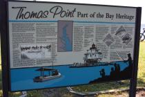
Inscription
Part Of The Bay Heritage
(Left side of the marker) Much of the early history of Thomas Point still lies buried under sand and water at its ever-eroding shoreline. Evidence does exist, however, that Native Americans enjoyed the bounty of the Bay's seafood sometime between 200 AD and 1500 AD. Large piles of oysters and other shellfish remains, known as middens, still mark the sites of those early harvests and feasts.The first white man known to settle the area was English merchant Philip Thomas, who owned many acres along what as then the shore of Anne Arundel Bay. Among the land parcels he was granted between 1658 and 1668 was a 165-acre tract called "Fuller Point." which later became Thomas Point. Thomas died in 1675 and was buried at the "Old Quaker Burial Ground" in Galesville, several miles from here in southern Anne Arundel County. His children later divided the estate.
Ownership of Thomas Point changed several times from then until 1824, when the U.S. government paid $529 for a 7-acre parcel on which to build a lighthouse. Eventually, private interests bought back what remained of the 7-acres in 1914.
In 1917, Mr. and Mrs. Charles F. Lee and Mr. and Mrs. Ridgley P. Melvin sold 72-acres-the present Thomas Point Park and community of Oakwood—to the Thomas Point Duck Club. The club's original manor house and various out-buildings still stand in Oakwood.
On the small farm that occupied Thomas Point at the time, the only crop known to have been grown was corn, which was probably raised to attract ducks. A small log cabin, which now serves as the park office and the park ranger's residence, was the hunting lodge for the duck club. This building still stands at Thomas Point, and the names of some prominent members of the duck club can be found carved into the frame of the cabin's 8-foot fireplace.
The duck club used the hunting lodge for 30 years, before it sold the property to Ferdinand C. and Jane Homer Lee in 1947.
Between 1960 and 1963, the Lees deeded their 44-acres to Anne Arundel County in four parcels at a price of $5.00 each with the stipulation that the property be used for recreation and conservation purpose. Thanks to their generosity, thousands of visitors each year have enjoyed the natural beauty of the park. And thousands more will see this part of the Chesapeake much the way Philip Thomas saw it over 300 years ago.
(Right side of the marker) The Thomas Point Lighthouse: A Bay Landmark. One of the most familiar landmarks of the Chesapeake is the Thomas Point Lighthouse. The present lighthouse stands approximately one mile off the end of the point, where it has steered boaters clear of the treacherous Thomas Point shoal since 1874. This structure is actually the third lighthouse to be built in the vicinity. The first began service in 1825 on land that eventually eroded away, at which time it was rebuilt in 1838. The current lighthouse is an unusual white hexagonal building complete with keeper's quarters. The iron pilings which anchor the lighthouse are literally screwed into the bottom of the Chesapeake Bay.
The Thomas Point lantern generates 6,000 candlepower of white light that is visible for up to 12 miles; boaters can see the 1,300 candlepower red light from approximately 9 miles away. The lighthouse also is equipped with a foghorn that sounds regularly during periods of low visibility.
A keeper manned the lighthouse until the mid-1980 when the light was automated with a generator and batteries.
Details
| HM Number | HM1S0R |
|---|---|
| Marker Condition | No reports yet |
| Date Added | Monday, May 2nd, 2016 at 9:03am PDT -07:00 |
Pictures
Photo Credits: [1] BRIDGER1963
Locationbig map
| UTM (WGS84 Datum) | 18S E 373365 N 4307531 |
|---|---|
| Decimal Degrees | 38.90755000, -76.46050000 |
| Degrees and Decimal Minutes | N 38° 54.453', W 76° 27.63' |
| Degrees, Minutes and Seconds | 38° 54' 27.18" N, 76° 27' 37.8" W |
| Driving Directions | Google Maps |
| Area Code(s) | 410, 443, 703, 240, 301 |
| Closest Postal Address | At or near 3890 Thomas Point Rd, Annapolis MD 21403, US |
| Alternative Maps | Google Maps, MapQuest, Bing Maps, Yahoo Maps, MSR Maps, OpenCycleMap, MyTopo Maps, OpenStreetMap |
Is this marker missing? Are the coordinates wrong? Do you have additional information that you would like to share with us? If so, check in.
Nearby Markersshow on map
Show me all markers in: Annapolis, MD | Anne Arundel County | 21403 | Maryland | United States of America
Our Abundant Chesapeake
Twin Oaks
From this spot, you can see 1998 - Annapolis: America's Sailing Capital
Oysters: Vital to Nature. Vital to Our Future.
Oysters: Vital to Commerce. Vital to Culture.
Oysters: Vital to the Lifeline of the Chesapeake
From this spot, you can see 1919 - Oysters: The Bay's "White Gold"
From this spot, you can see 1887 - The Age of Steam
From this spot, you can see 1608 - Captain John Smith's Chesapeake Voyages
From this spot, you can see 1672 - Providence: Settlement on the Severn
Maintenance Issues
- Is this marker part of a series?
- This markers needs some tags to help categorize the marker
- What historical period does the marker represent?
- What historical place does the marker represent?
- What type of marker is it?
- What class is the marker?
- What style is the marker?
- Does the marker have a number?
- What year was the marker erected?
- Who or what organization placed the marker?
- This marker could use another picture or two.
- Can this marker be seen from the road?
- Is the marker in the median?

Comments 0 comments