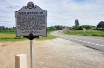
Inscription
Mile stone 46
East of this point is mile stone 46 on the line marked by English surveyors and astronomers Charles Mason and Jeremiah Dixon. From 1763-1768 Mason and Dixon used innovative methods to settle a boundary dispute between the colonial proprietors. Each mile of line was set with carved stones brought from England. The Mason and Dixon line defined the border of Pennsylvania, Maryland and Delaware, and was part of the boundary separating free and slave-holding states before the Civil War.Details
| HM Number | HM1T7J |
|---|---|
| Tags | |
| Historical Period | Colonial |
| Historical Place | Other |
| Marker Type | Other |
| Marker Class | Historical Marker |
| Marker Style | Free Standing |
| Year Placed | 2015 |
| Placed By | Maryland Historical Trust-Maryland State Highway Administration |
| Marker Condition | No reports yet |
| Date Added | Sunday, July 24th, 2016 at 1:02pm PDT -07:00 |
Pictures
Photo Credits: [1] SEPTEMBERSPARROW1666 [2] SEPTEMBERSPARROW1666
Locationbig map
| UTM (WGS84 Datum) | 18S E 357930 N 4398112 |
|---|---|
| Decimal Degrees | 39.72106667, -76.65760000 |
| Degrees and Decimal Minutes | N 39° 43.264', W 76° 39.456' |
| Degrees, Minutes and Seconds | 39° 43' 15.8400" N, 76° 39' 27.3600" W |
| Driving Directions | Google Maps |
| Area Code(s) | 410 |
| Can be seen from road? | Yes |
| Is marker in the median? | No |
| Which side of the road? | Marker is on the right when traveling North |
| Closest Postal Address | At or near 21710 York Rd, Freeland MD 21053, US |
| Alternative Maps | Google Maps, MapQuest, Bing Maps, Yahoo Maps, MSR Maps, OpenCycleMap, MyTopo Maps, OpenStreetMap |
Is this marker missing? Are the coordinates wrong? Do you have additional information that you would like to share with us? If so, check in.
Nearby Markersshow on map
Show me all markers in: Freeland, MD | Baltimore County | 21053 | Maryland | United States of America
Related Markers
Maintenance Issues
- Is this marker part of a series?
- This marker could use another picture or two.


Comments 0 comments