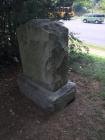
Inscription
1780
In Memoriam, Jane Parks, wife of Capt. John McDowell, Who rode 10 perilous miles to notify American Camp of the British evacuation of Charlotte. Erected by the Mecklenburg Chapter, DAR.
In Memoriam, Jane Parks, wife of Capt. John McDowell, Who rode 10 perilous miles to notify American Camp of the British evacuation of Charlotte. Erected by the Mecklenburg Chapter, DAR.
Details
| HM Number | HM1W9U |
|---|---|
| Additional Information | As the story goes, Jane Parks McDowell rode ten miles at night to notify the Patriots, who were camping north of Charlotte on the old Salisbury Road (also mentioned as Sugar Creek), that Cornwallis had evacuated Charlotte upon receiving word of the British Defeat at Kings Mountain. |
| Tags | |
| Historical Period | Revolutionary |
| Historical Place | Memorial |
| Marker Type | Memorial |
| Marker Class | Historical Marker |
| Marker Style | Carved Stone |
| Year Placed | 1916 |
| Placed By | Mecklenburg Chapter DAR |
| Marker Condition | No reports yet |
| Date Added | Tuesday, December 13th, 2016 at 11:05am PST -08:00 |
Pictures
Locationbig map
| Location Description | On the site of the home of Jane and John McDowell, and 8 generations of the McDowell family thereafter. |
|---|---|
| UTM (WGS84 Datum) | 44S E 492748 N 3890645 |
| Decimal Degrees | 35.15870000, -80.92037400 |
| Degrees and Decimal Minutes | N 35° 9.522', W 80° 55.2224' |
| Degrees, Minutes and Seconds | 35° 9' 31.3200" N, 80° 55' 13.3464" W |
| Driving Directions | Google Maps |
| Area Code(s) | 704, 919, 980 |
| Can be seen from road? | Yes |
| Is marker in the median? | No |
| Which side of the road? | Marker is on the right when traveling North |
| Closest Postal Address | At or near 7001 S Tryon St, Charlotte NC 28217, US |
| Alternative Maps | Google Maps, MapQuest, Bing Maps, Yahoo Maps, MSR Maps, OpenCycleMap, MyTopo Maps, OpenStreetMap |
Is this marker missing? Are the coordinates wrong? Do you have additional information that you would like to share with us? If so, check in.
Nearby Markersshow on map
Show me all markers in: Charlotte, NC | Mecklenburg County | 28217 | North Carolina | United States of America
Maintenance Issues
- Is this marker part of a series?


Comments 0 comments