| HM Number | HM2042 |
|---|---|
| Tags | |
| Year Placed | 1972 |
| Placed By | Michigan Historical Commission, Department of State |
| Marker Condition |           7 out of 10 (1 reports) |
| Date Added | Tuesday, July 25th, 2017 at 1:02pm PDT -07:00 |
| UTM (WGS84 Datum) | 16T E 418253 N 5076511 |
|---|---|
| Decimal Degrees | 45.83731667, -88.05263333 |
| Degrees and Decimal Minutes | N 45° 50.239', W 88° 3.158' |
| Degrees, Minutes and Seconds | 45° 50' 14.34" N, 88° 3' 9.48" W |
| Driving Directions | Google Maps |
| Area Code(s) | 906 |
| Closest Postal Address | At or near Antoine St, Iron Mountain MI 49801, US |
| Alternative Maps | Google Maps, MapQuest, Bing Maps, Yahoo Maps, MSR Maps, OpenCycleMap, MyTopo Maps, OpenStreetMap |
Is this marker missing? Are the coordinates wrong? Do you have additional information that you would like to share with us? If so, check in.
I Saw The Marker
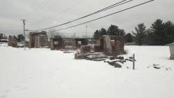
This upright, freestanding marker is behind the Comfort Inn. It is not visible from the road although the ruins of the furnace can be seen from the road. It is the typical Michigan historical marker a double sided metal plaque, about 3 feet by 3 feet, supported by aluminum poles on either side.
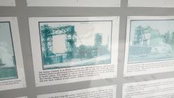
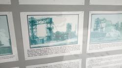
Not much left of the Furnace, just several cement supports. There is a separate freestanding display board with more information and historical photos showing how it looked when in operation.
Dec 27, 2018 at 2:24pm PST by scotty
- Is this marker part of a series?
- What historical period does the marker represent?
- What historical place does the marker represent?
- What type of marker is it?
- What class is the marker?
- What style is the marker?
- Does the marker have a number?
- Can this marker be seen from the road?
- Is the marker in the median?


Comments 0 comments