Inscription
Independence National Historical Park
The grassy depression in front of you marks the location of Dock Creek, a spring-fed, tidal stream that flowed here when Philadelphia was founded. Its waters emptied into the Delaware River about four blocks ahead of you.By 1767, city wastes had fouled the water so badly that sections of the creek were arched over and covered by Dock Street. Today only traces of the creek bed remain.Details
| HM Number | HM20BV |
|---|---|
| Tags | |
| Placed By | Independence National Historical Park |
| Marker Condition | No reports yet |
| Date Added | Tuesday, August 1st, 2017 at 10:01pm PDT -07:00 |
Pictures
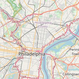
Locationbig map

| UTM (WGS84 Datum) | 18S E 487445 N 4421986 |
|---|---|
| Decimal Degrees | 39.94791667, -75.14696667 |
| Degrees and Decimal Minutes | N 39° 56.875', W 75° 8.818' |
| Degrees, Minutes and Seconds | 39° 56' 52.5" N, 75° 8' 49.08" W |
| Driving Directions | Google Maps |
| Area Code(s) | 267, 484, 215, 610 |
| Which side of the road? | Marker is on the right when traveling North |
| Closest Postal Address | At or near 128 S 3rd St, Philadelphia PA 19106, US |
| Alternative Maps | Google Maps, MapQuest, Bing Maps, Yahoo Maps, MSR Maps, OpenCycleMap, MyTopo Maps, OpenStreetMap |
Is this marker missing? Are the coordinates wrong? Do you have additional information that you would like to share with us? If so, check in.
Nearby Markersshow on map
Show me all markers in: Philadelphia, PA | Philadelphia County | 19106 | Pennsylvania | United States of America
Maintenance Issues
- Is this marker part of a series?
- What historical period does the marker represent?
- What historical place does the marker represent?
- What type of marker is it?
- What class is the marker?
- What style is the marker?
- Does the marker have a number?
- What year was the marker erected?
- This marker needs at least one picture.
- Can this marker be seen from the road?
- Is the marker in the median?
Comments 0 comments