Inscription
New Road was new in 1770, built by a turnpike trust as a western exit from the city centre. It sliced through the former Oxford Castle bailey (the open space within the castle walls), providing an ideal site for what became the city's principal canal basin and coal wharves.
Lord Nuffield bought the canal basin in 1937 and Nuffield College now occupies the site of the coal wharf. The castle mound (or motte) built in 1071 still dominates the far side of New Road but, standing here in medieval times, you would have been looking across the defensive moat and outer wall towards a 13th century stone keep on top of the mound.
Oxford Castle — a Norman stronghold
The grassy hill behind you is the mound of Oxford Castle, built in 1071 to assert the rights of the Norman conquerors. Initially, there wasa timber keep on the mound but this was replaced by a ten-sided stone keep in the 13th century. The defensive moat and outer wall at this point ran alongside what is now Tidmarsh Lane and then past the base of the mound.
King Stephen's forces besieged the castle in 1142 when his rival, Empress Matilda, was famously forced to escape by fleeing down the frozen Thames camouflaged in white. There was a further siege in 1216 but the castle was then allowed to decay until the Civil War in the 1640s when it was refortified.
The Parliamentarians finally destroyed it as a stronghold in 1651. Oxford Castle was used as a prison as early as the 12th century and this role continued long after the castle's military value declined. A county jail was built on the site from 1785-1805 and it remained a place of incarceration for about 200 years before being closed in 1996. Oxford Castle, hidden for centuries, was restored and opened to public view in 2006 while the former prison was converted into a luxury hotel!
The canal wharf that became a college
By 1790 the Oxford Canal coal wharf was dug into the area to your left by prisoners from the county jail. The wharf remained until 1937 when Lord Nuffield, car manufacturer and philanthropist, bought the site for his proposed college - also donating £900,000 (c. £250 million in today's money) to build and endow it. Nuffield College wasn't finished until well after the Second World War due to building restrictions. Despite being one of the youngest colleges, its architecture was modelled on the traditional college layout, while its modernist spire proved a fine addition to the Oxford skyline. The original plan was for college buildings on both sides of Worcester Street, but to this day the area west of the college is occupied by a 'temporary' car park. Few features survive from the canal era and the truncated Oxford Canal now terminates
at Hythe Bridge Street.
Building Blocks
Oxford was well defended in the Middle Ages. The remains of the castle mound are nearby. Behind them St George's tower still stands strong with its 2.5 metre thick walls.
Standing here 900 years ago you would have been behind the castle walls
in the castle grounds.
Details
| HM Number | HM2C0T |
|---|---|
| Tags | |
| Marker Condition | No reports yet |
| Date Added | Saturday, October 6th, 2018 at 8:01pm PDT -07:00 |
Pictures
Locationbig map


| UTM (WGS84 Datum) | 30U E 619853 N 5734976 |
|---|---|
| Decimal Degrees | 51.75285000, -1.26363333 |
| Degrees and Decimal Minutes | N 51° 45.171', W 1° 15.818' |
| Degrees, Minutes and Seconds | 51° 45' 10.26" N, 1° 15' 49.08" W |
| Driving Directions | Google Maps |
| Which side of the road? | Marker is on the right when traveling West |
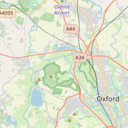
| Closest Postal Address | At or near 314 New Rd, England OX1 2AA, GB |
| Alternative Maps | Google Maps, MapQuest, Bing Maps, Yahoo Maps, MSR Maps, OpenCycleMap, MyTopo Maps, OpenStreetMap |
Is this marker missing? Are the coordinates wrong? Do you have additional information that you would like to share with us? If so, check in.
Maintenance Issues
- Is this marker part of a series?
- What historical period does the marker represent?
- What historical place does the marker represent?
- What type of marker is it?
- What class is the marker?
- What style is the marker?
- Does the marker have a number?
- What year was the marker erected?
- Who or what organization placed the marker?
- This marker needs at least one picture.
- Can this marker be seen from the road?
- Is the marker in the median?
Comments 0 comments