Inscription
Dedicated Nov. 2, 1930.
to the memory of the
Four Hundred Children of
St. Mary Magdalen Parish
buried in this plot
1859 - 1889.
'Suffer children to come to me, and forbid them
not. For such is the kingdom of God.'
Luke XVIII-16
Details
| HM Number | HM2DO6 |
|---|---|
| Tags | |
| Year Placed | 1930 |
| Placed By | Saint Mary Magdalen Parish |
| Marker Condition | No reports yet |
| Date Added | Friday, January 18th, 2019 at 1:01pm PST -08:00 |
Pictures
Locationbig map
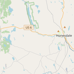


| UTM (WGS84 Datum) | 18T E 478221 N 4604000 |
|---|---|
| Decimal Degrees | 41.58740000, -75.26128333 |
| Degrees and Decimal Minutes | N 41° 35.244', W 75° 15.677' |
| Degrees, Minutes and Seconds | 41° 35' 14.64" N, 75° 15' 40.62" W |
| Driving Directions | Google Maps |
| Area Code(s) | 570 |
| Which side of the road? | Marker is on the right when traveling North |
| Closest Postal Address | At or near 1802 Fair Ave, Honesdale PA 18431, US |
| Alternative Maps | Google Maps, MapQuest, Bing Maps, Yahoo Maps, MSR Maps, OpenCycleMap, MyTopo Maps, OpenStreetMap |
Is this marker missing? Are the coordinates wrong? Do you have additional information that you would like to share with us? If so, check in.
Nearby Markersshow on map
Show me all markers in: Honesdale, PA | Wayne County | 18431 | Pennsylvania | United States of America
Stourbridge Lion
Snubbing Post Historical
The Stourbridge Lion Historical
1829 Stourbridge Lion
The Tallman Bridge Historical
Heroes of 1776-Residents of Wayne County
Wayne County World War I Memorial, a War Memorial
Wayne Memorial Hospital, a War Memorial
Gibbons Memorial Park
First Baptist Church Historical
Maintenance Issues
- Is this marker part of a series?
- What historical period does the marker represent?
- What historical place does the marker represent?
- What type of marker is it?
- What class is the marker?
- What style is the marker?
- Does the marker have a number?
- This marker needs at least one picture.
- Can this marker be seen from the road?
- Is the marker in the median?
Comments 0 comments