Inscription
Rumored to have been a slave cemetery, this burial ground is the final resting place of several white and black residents of Gum Springs.
In 1762, Humphrey Peake inherited three slaves — Caesar, Ben and Allee; a mare named Flower, five leather chairs, a silk rug, and 150 acres on Little Hunting Creek from the estate of his father William Peake. The elder Peake and Augustine Washington, George Washington's father, were fellow Truro Parish vestrymen. Humphrey Peake continued his family's long friendship with their Mt. Vernon neighbors until his death. Peake was buried on this site in 1785 followed by his son William in 1793, his niece Kitty Adams in 1797, and his wife Mary Stonestreet Peake in 1805.
Two of the gravesites here belong to heirs of West Ford, who as a child was a slave at Mt. Vernon. Granted his freedom in 1805, Ford received 160 acres of marshland upon the death of Bushrod Washington, the General's nephew, in 1829. Four years later, West Ford sold his property to purchase another 214 acres at Gum Springs. By 1880, 12 families of freed blacks and Ford descendants inhabited the community. Two of these, William Dandridge Smith, a farmer, and his wife Annie, a schoolteacher, owned a six-room house and a 14-acre lot. Together they may have earned an annual income of $600. Dandridge Smith was buried
in this cemetery in 1906. Annie Smith was laid to rest near her husband in 1907.
The three remaining headstones belong to Elizabeth Clements, Edith Anderson and Emily Alexander who were interred in the Peake Family Cemetery between 1825 and 1884. Their kinship to the Ford family is unkown.
Details
| HM Number | HM2F8B |
|---|---|
| Tags | |
| Placed By | Fairfax County Park Authority, Division of Historic Preservation |
| Marker Condition | No reports yet |
| Date Added | Friday, March 29th, 2019 at 5:01pm PDT -07:00 |
Pictures
Locationbig map
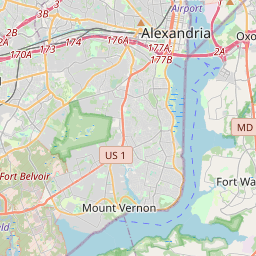

| UTM (WGS84 Datum) | 18S E 318868 N 4289661 |
|---|---|
| Decimal Degrees | 38.73706667, -77.08400000 |
| Degrees and Decimal Minutes | N 38° 44.224', W 77° 5.04' |
| Degrees, Minutes and Seconds | 38° 44' 13.44" N, 77° 5' 2.4" W |
| Driving Directions | Google Maps |
| Closest Postal Address | At or near , , |
| Alternative Maps | Google Maps, MapQuest, Bing Maps, Yahoo Maps, MSR Maps, OpenCycleMap, MyTopo Maps, OpenStreetMap |
Is this marker missing? Are the coordinates wrong? Do you have additional information that you would like to share with us? If so, check in.
Nearby Markersshow on map
Maintenance Issues
- What country is the marker located in?
- Is this marker part of a series?
- What historical period does the marker represent?
- What historical place does the marker represent?
- What type of marker is it?
- What class is the marker?
- What style is the marker?
- Does the marker have a number?
- What year was the marker erected?
- This marker needs at least one picture.
- Can this marker be seen from the road?
- Is the marker in the median?
Comments 0 comments