Inscription
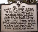
This church, formally organized in 1839, had its origins in a slave mission begun in 1786 on Gov. Thomas Boone's plantation, 3 miles SE. Rev. P. A. M. Williams became its first minister in 1840. The first Church, a frame building built the same year, stood 1.5 miles S. The present sanctuary was built on a 5-acre plot donated to the church in 1887 by Benjamin D. Bourne, a member and trustee.
The present sanctuary, built by the time the congregation acquired this site in 1887, was originally a frame church. It was extensively renovated in 1859-60 and completely covered in brick in 1975-76. Three members of the church later became ministers: Revs. C. D. Huggins, Jack D. Watts, and John Paul Watts, Sr. Sampit is also the mother church of Oak Grove Methodist Church, founded in 1890.
The present sanctuary, built by the time the congregation acquired this site in 1887, was originally a frame church. It was extensively renovated in 1859-60 and completely covered in brick in 1975-76. Three members of the church later became ministers: Revs. C. D. Huggins, Jack D. Watts, and John Paul Watts, Sr. Sampit is also the mother church of Oak Grove Methodist Church, founded in 1890.
Details
| HM Number | HMB3Z |
|---|---|
| Tags | |
| Historical Period | Colonial, 20th Century, 19th Century, 18th Century, 17th Century, 16th Century |
| Historical Place | Plantation, Church/House of Worship, Cemetery |
| Marker Type | Historic Building |
| Marker Class | Historical Marker |
| Marker Style | Free Standing |
| Marker Number | 22-56 |
| Year Placed | 2003 |
| Placed By | The congregation |
| Marker Condition |           10 out of 10 (1 reports) |
| Date Added | Thursday, September 18th, 2014 at 6:19pm PDT -07:00 |
Pictures
Photo Credits: [1] SOP2510 [2] GOOGLE EARTH
Locationbig map
| Directions Information | US 521N to Alternate US-17N |
|---|---|
| Location Description | Two-lane blacktop road. Parking available in the church lot. |
| UTM (WGS84 Datum) | 17S E 643459 N 3692741 |
| Decimal Degrees | 33.36435000, -79.45800000 |
| Degrees and Decimal Minutes | N 33° 21.861', W 79° 27.48' |
| Degrees, Minutes and Seconds | 33° 21' 51.6600" N, 79° 27' 28.8000" W |
| Driving Directions | Google Maps |
| Area Code(s) | 843 |
| Can be seen from road? | Yes |
| Is marker in the median? | No |
| Which side of the road? | Marker is on the right when traveling South |
| Closest Postal Address | At or near 1292 Saints Delight Rd, Georgetown SC 29440, US |
| Alternative Maps | Google Maps, MapQuest, Bing Maps, Yahoo Maps, MSR Maps, OpenCycleMap, MyTopo Maps, OpenStreetMap |
Is this marker missing? Are the coordinates wrong? Do you have additional information that you would like to share with us? If so, check in.
Nearby Markersshow on map
Show me all markers in: Georgetown, SC | Georgetown County | 29440 | South Carolina | United States of America
Maintenance Issues
- Is this marker part of a series?
- This marker could use another picture or two.


Comments 0 comments