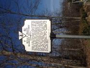
Inscription
...held to the bluff without room to retire.
Two hundred yards to your right are the remains of a small earthwork that may have been part of a masked (concealed) battery which played an important role in the Battle of Ball's Bluff on October 21, 1861. The battery commanded the road from Edwards Ferry on the Potomac River to the town of Leesburg. Union Gen. Charles P. Stone, seeking to reconnoiter Confederate defenses near Leesburg, sent forces commanded by Col. Edward D. Baker across the Potomac about a mile north at Ball's Bluff. Baker, a U.S. Senator with little military experience, deployed his troops poorly and soon came under heavy attack by the Confederates, commanded by Col. Nathan P. "Shanks" Evans.Whoever controlled the roadway behind you could control the flow of reinforcements to the battlefield from both Edwards Ferry and Confederate Fort Evans. As the battle began, Stone, then at Edwards Ferry, sent 35 cavalrymen of the 3rd New York Cavalry under Maj. John Mix to scout the road between the ferry and Leesburg. Having learned of the masked battery, Stone ordered Mix to reconnoiter the terrain around it to discover Confederate troop dispositions and to study routes "for the passage of troops," then withdrew. Just east of here, Mix's detachment took fire from elements of Col. William Barksdale's 13th Mississippi Infantry. The Confederates held the road for the rest of the day, reinforced their troops facing Baker, and contributed to the defeat of the Union soldiers atop Ball's Bluff.
Details
| HM Number | HMBC |
|---|---|
| Series | This marker is part of the Virginia Civil War Trails series, and the Department of historical resources series. |
| Tags | |
| Historical Period | Civil War |
| Historical Place | Battlefield |
| Marker Type | Other |
| Marker Class | Both |
| Marker Style | Free Standing |
| Marker Number | T-51 |
| Year Placed | 2005 |
| Placed By | Virginia Civil War Trails |
| Marker Condition | No reports yet |
| Date Added | Sunday, October 26th, 2014 at 10:13pm PDT -07:00 |
Locationbig map


| Directions Information | Edwards ferry road NE leesburg VA 20176 |
|---|---|
| Location Description | Edwards landing community |
| UTM (WGS84 Datum) | 18S E 281556 N 4332463 |
| Decimal Degrees | 39.11396667, -77.52656667 |
| Degrees and Decimal Minutes | N 39° 6.838', W 77° 31.594' |
| Degrees, Minutes and Seconds | 39° 6' 50.2800" N, 77° 31' 35.6400" W |
| Driving Directions | Google Maps |
| Area Code(s) | 703, 540, 571 |
| Can be seen from road? | Yes |
| Is marker in the median? | No |
| Which side of the road? | Marker is on the right when traveling West |
| Closest Postal Address | At or near 42626-42684 State Rte 773, Leesburg VA 20176, US |
| Alternative Maps | Google Maps, MapQuest, Bing Maps, Yahoo Maps, MSR Maps, OpenCycleMap, MyTopo Maps, OpenStreetMap |
Is this marker missing? Are the coordinates wrong? Do you have additional information that you would like to share with us? If so, check in.
Nearby Markersshow on map
Maintenance Issues
- This marker could use another picture or two.


Comments 0 comments