Inscription
In this mountain gap, through which came early pioneers, Gen. W.W. Loring camped, 1861, with 10,000 Confederates. In July, Gen. Robert E. Lee succeeded him. North and south is the mountain road which offers a remarkable sky line drive.
Details
| HM Number | HMMUM |
|---|---|
| Tags | |
| Year Placed | 2009 |
| Placed By | West Virginia Department of Archives and History |
| Marker Condition |  10 out of 10 (1 reports) |
| Date Added | Wednesday, October 15th, 2014 at 1:56am PDT -07:00 |
Pictures
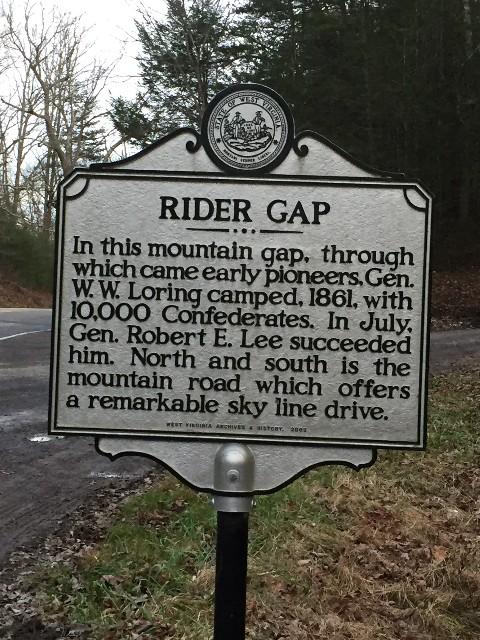
Photo Credits: [1] THOMAS E RIDER
Locationbig map
| UTM (WGS84 Datum) | 17S E 592539 N 4220040 |
|---|---|
| Decimal Degrees | 38.12346667, -79.94423333 |
| Degrees and Decimal Minutes | N 38° 7.408', W 79° 56.654' |
| Degrees, Minutes and Seconds | 38° 7' 24.48" N, 79° 56' 39.24" W |
| Driving Directions | Google Maps |
| Area Code(s) | 304 |
| Closest Postal Address | At or near 402-408 Pub Rd 55, Marlinton WV 24954, US |
| Alternative Maps | Google Maps, MapQuest, Bing Maps, Yahoo Maps, MSR Maps, OpenCycleMap, MyTopo Maps, OpenStreetMap |
Is this marker missing? Are the coordinates wrong? Do you have additional information that you would like to share with us? If so, check in.
Nearby Markersshow on map
I Saw The Marker
This Gap is where Alexander W Rider and his wife Isabella Sharp Rider lived from 1830 until his death in 1892. The remains of the old homeplace are located in the field at the intersection of Rt 92 and Rt 39 just a few hundred yards from the marker.
Jan 4, 2016 at 8:29am PST by deedplot
Comments 1 comments
Maintenance Issues
- Is this marker part of a series?
- What historical period does the marker represent?
- What historical place does the marker represent?
- What type of marker is it?
- What class is the marker?
- What style is the marker?
- Does the marker have a number?
- This marker could use another picture or two.
- Can this marker be seen from the road?
- Is the marker in the median?
This Gap is where Alexander W Rider and his wife Isabella Sharp Rider lived from 1830 until his death in 1892. The remains of the old homeplace are located in the field at the intersection of Rt 92 and Rt 39 just a few hundred yards from the marker.
Alex purchased 1200 acres at this site in 1830 and lived there until his death in 1892. By the time of his death he had acquired over 4000 acres in this area. He maintained a black smith shop and offered corrals for farmers driving their turkeys, sheep, cattle and pigs over to Warm Springs VA to get them to market in eastern Virginia.
Upon his death the land was sold and divided among his 6 great grand children. It is rumored that he left a large sum of gold and silver buried in these mountains that has not been found to this day.
During the great depression there was a African American CCC camp in the field that was closed after about 18 months.