Inscription
1630 - 1930
Built in 1742 for defence against French cruisers. U.S.S. "Constitution" sought shelter under the fort's guns when chased by H.M.S. "Tenedos" and "Endymion" April 3, 1814. Named after Samuel Sewall of Marblehead, Chief Justice of Massachusetts in 1814.Details
| HM Number | HMWAZ |
|---|---|
| Series | This marker is part of the Massachusetts: Massachusetts Bay Colony—Tercentenary Commission Markers series |
| Tags | |
| Year Placed | 1930 |
| Placed By | Massachusetts Bay Colony-Tercentenary Commission |
| Marker Condition | No reports yet |
| Date Added | Wednesday, October 8th, 2014 at 1:56am PDT -07:00 |
Pictures
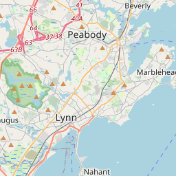
Locationbig map


| UTM (WGS84 Datum) | 19T E 348606 N 4707878 |
|---|---|
| Decimal Degrees | 42.50846667, -70.84275000 |
| Degrees and Decimal Minutes | N 42° 30.508', W 70° 50.565' |
| Degrees, Minutes and Seconds | 42° 30' 30.48" N, 70° 50' 33.90" W |
| Driving Directions | Google Maps |
| Area Code(s) | 781, 617 |
| Closest Postal Address | At or near 6-98 Fort Sewall Ln, Marblehead MA 01945, US |
| Alternative Maps | Google Maps, MapQuest, Bing Maps, Yahoo Maps, MSR Maps, OpenCycleMap, MyTopo Maps, OpenStreetMap |
Is this marker missing? Are the coordinates wrong? Do you have additional information that you would like to share with us? If so, check in.
Nearby Markersshow on map
Maintenance Issues
- What historical period does the marker represent?
- What historical place does the marker represent?
- What type of marker is it?
- What class is the marker?
- What style is the marker?
- Does the marker have a number?
- This marker needs at least one picture.
- Can this marker be seen from the road?
- Is the marker in the median?
Comments 0 comments