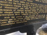
By the early 1880s Lake Minnetonka had become a favorite summer resort for the rich and famous of the United States and Europe, including Presidents Ulysses S. Grant and Chester A. Arthur. The 300-foot "Belle of Minnetonka" and other excursion boats nearly as large carried thousands of visitors enjoying holidays at comfortable summer homes or elegant hotels like the Chapman House here on Cook's Bay and the prestigious Hotel Lafayette on Crystal Bay.
With the arrival of the automobile, the great hotel era faded and the summer cottages evolved into permanent homes. Lake Minnetonka is still known for its beauty and its many recreational opportunities.
Erected by the Minnesota Historical Society
and the Westonka Historical Society - 1985
| HM Number | HM148Y |
|---|---|
| Tags | |
| Year Placed | 1985 |
| Placed By | The Minnesota Historical Society and the Westonka Historical Society |
| Marker Condition |           0 out of 10 (1 reports) |
| Date Added | Tuesday, September 2nd, 2014 at 8:44am PDT -07:00 |
| UTM (WGS84 Datum) | 15T E 447059 N 4975232 |
|---|---|
| Decimal Degrees | 44.92855000, -93.67086667 |
| Degrees and Decimal Minutes | N 44° 55.713', W 93° 40.252' |
| Degrees, Minutes and Seconds | 44° 55' 42.78" N, 93° 40' 15.12" W |
| Driving Directions | Google Maps |
| Area Code(s) | 952, 612, 763 |
| Closest Postal Address | At or near 5801 Bartlett Blvd, Mound MN 55364, US |
| Alternative Maps | Google Maps, MapQuest, Bing Maps, Yahoo Maps, MSR Maps, OpenCycleMap, MyTopo Maps, OpenStreetMap |
Is this marker missing? Are the coordinates wrong? Do you have additional information that you would like to share with us? If so, check in.
I Saw The Marker
In May, 1822, a Fort Snelling drummer boy named Joseph R. Brown and his friend, William Snelling, son of the fort's commander, canoed up what is now called Minnehaha Creek to "discover" a lake long sacred to the Indian people who built burial mounds along its shores.
May 22, 2017 at 1:27pm PDT by westonkaagent
- Is this marker part of a series?
- What historical period does the marker represent?
- What historical place does the marker represent?
- What type of marker is it?
- What class is the marker?
- What style is the marker?
- Does the marker have a number?
- This marker could use another picture or two.
- Can this marker be seen from the road?
- Is the marker in the median?


Comments 0 comments