Inscription
7, 9 & 11 West Mount Vernon Place
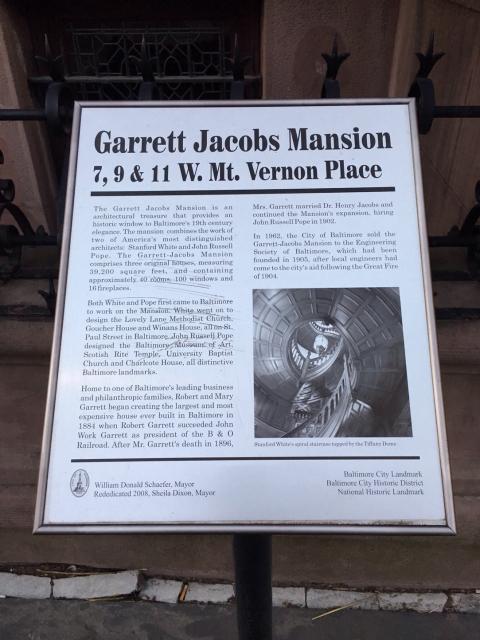
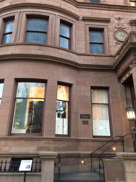
The Garrett Jacobs Mansion is an architectural treasure that provides an historic window to Baltimore's 19th century elegance. The mansion combines the work of two of America's most distinguished architects: Stanford White and John Russell Pope. The Garrett-Jacobs Mansion comprises three original houses, measuring 39,200 square feet, and containing approximately 40 rooms, 100 windows and 16 fireplaces.
Both White and Pope first came to Baltimore to work on the Mansion. White went on to design the Lovely Lane Methodist Church, Goucher House and Winans House, all on St. Paul Street in Baltimore. John Russell Pope designed the Baltimore Museum of Art, Scotish Rite Temple, University Baptist Church and Charlcote House, all distinctive Baltimore landmarks.
Home to one of the Baltimore's leading business and philanthropic families, Robert and Mary Garrett began creating the largest and most expensive house ever built in Baltimore in 1884 when Robert Garrett succeeded John Work Garrett as president of the B&O Railroad. After Mr. Garrett's death in 1896, Mrs. Garrett married Dr. Henry Jacobs and continued the Mansion's expansion, hiring John Russell Pope in 1902.
In 1962, the City of Baltimore sold the Garrett-Jacobs Mansion to the Engineering Society of Baltimore, which had been founded in 1905, after local engineers had come to the city's aid following the Great Fire of 1904.
(Photo) Stanford White's spiral staircase topped by the Tiffany Dome.William Donald Schaefer, Mayor-Rededicated 2008, Sheila Dixon, Mayor-Baltimore City Landmark-Baltimore City Historic District-National Historic Landmark
Details
| HM Number | HM16EI |
|---|---|
| Series | This marker is part of the National Historic Landmarks series, and the Arizona: Pistols, Plows and Petticoats Historic Driving Tour series. |
| Tags | |
| Historical Period | 19th Century |
| Historical Place | National Register of Historic Places, Home |
| Marker Type | Historic Home |
| Marker Class | Historical Marker |
| Marker Style | Free Standing |
| Year Placed | 2008 |
| Placed By | Mayor-City of Baltimore |
| Marker Condition | No reports yet |
| Date Added | Sunday, September 21st, 2014 at 6:15am PDT -07:00 |
Pictures

Locationbig map
| UTM (WGS84 Datum) | 18S E 360591 N 4351037 |
|---|---|
| Decimal Degrees | 39.29750000, -76.61670000 |
| Degrees and Decimal Minutes | N 39° 17.85', W 76° 37.002' |
| Degrees, Minutes and Seconds | 39° 17' 51.0000" N, 76° 37' 0.1200" W |
| Driving Directions | Google Maps |
| Area Code(s) | 410, 443, 301 |
| Can be seen from road? | Yes |
| Is marker in the median? | No |
| Which side of the road? | Marker is on the right when traveling East |
| Closest Postal Address | At or near 54-98 W Mt Vernon Pl, Baltimore MD 21201, US |
| Alternative Maps | Google Maps, MapQuest, Bing Maps, Yahoo Maps, MSR Maps, OpenCycleMap, MyTopo Maps, OpenStreetMap |
Is this marker missing? Are the coordinates wrong? Do you have additional information that you would like to share with us? If so, check in.
Comments 0 comments