Inscription
Star-Spangled Banner National Historic Trail
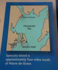
During the War of 1812, Havre de Grace was a fishing village, but also played host to many travelers. The Post Road, the main route of land travel in the day, came through town, and travelers used the local ferry at the north end of town to cross the Susquehanna River.When the British docked at Spesutia Island, Havre de Grace residents went on high alert, but lost their urgency after a few days of safety.
"Vigilance continued till within three or four days of the time when they were actually attacked. At this time, the inhabitants, wearied with continual excitement and laborious exercise, began to relax from their exertions..."
Jared Sparks,
North American Review and Miscellaneous Journal 14, 1817
John Boyd was the first to see the British as they approached under the cover of night on May 3, 1813. He "gave the alarm to the sentinels, who were stationed near to his house."
Details
| HM Number | HM17KY |
|---|---|
| Series | This marker is part of the Star Spangled Banner National Historic Trail series |
| Tags | |
| Historical Period | 19th Century |
| Historical Place | Military Installation |
| Marker Type | Other |
| Marker Class | Historical Marker |
| Marker Style | Free Standing |
| Placed By | National Park Service, Department of the Interior |
| Marker Condition | No reports yet |
| Date Added | Saturday, September 20th, 2014 at 2:00pm PDT -07:00 |
Pictures
Photo Credits: [1] SEPTEMBERSPARROW1666 [2] SEPTEMBERSPARROW1666 [3] SEPTEMBERSPARROW1666 [4] SEPTEMBERSPARROW1666 [5] SEPTEMBERSPARROW1666
Locationbig map


| UTM (WGS84 Datum) | 18S E 406475 N 4377084 |
|---|---|
| Decimal Degrees | 39.53833333, -76.08835000 |
| Degrees and Decimal Minutes | N 39° 32.3', W 76° 5.301' |
| Degrees, Minutes and Seconds | 39° 32' 18.0000" N, 76° 5' 18.0600" W |
| Driving Directions | Google Maps |
| Area Code(s) | 443, 410 |
| Can be seen from road? | No |
| Is marker in the median? | No |
| Closest Postal Address | At or near Havre de Grace Promenade, Havre de Grace MD 21078, US |
| Alternative Maps | Google Maps, MapQuest, Bing Maps, Yahoo Maps, MSR Maps, OpenCycleMap, MyTopo Maps, OpenStreetMap |
Is this marker missing? Are the coordinates wrong? Do you have additional information that you would like to share with us? If so, check in.
Nearby Markersshow on map
Show me all markers in: Havre de Grace, MD | Harford County | 21078 | Maryland | United States of America
Maintenance Issues
- Which side of the road is the marker located?


Comments 0 comments