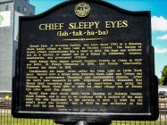
Inscription
(Ish-tak-ha-ba)
Sleepy Eyes, or Drooping Eyelids, was born about 1780 in a Sisseton Sioux Indian village at Swan Lake in Nicollet County. The Bureau of Indian Affairs commissioned him a chief in 1824. His fame was achieved not as a warrior or hunter but as a friend to explorers, traders, missionaries, and government officials.
Chief Sleepy Eyes signed several treaties - Prairie du Chien in 1825 and 1830, St. Peters (Mendota) in 1836, and finally, reluctantly, Traverse des Sioux in 1851.
Traditionally his band, often called the Swan Lake or Little Rock band, hunted over a broad area between Swan Lake and Coteau des Prairies in southwestern Minnesota and southeastern Dakota. After the Spirit Lake massacre in 1857, frightened settlers demanded that Sleepy Eyes' wandering band remain on reservation land along the Minnesota River. From 1857 to 1859 his chief village was at Sleepy Eye Lake, near this plaque.
Sleepy Eyes died about 1860 while hunting in Roberts County, South Dakota, and is not to be confused with a nephew of the same name who was implicated in the uprising in 1862. In 1898 the old chief's grave was located, and in 1902 he was re-buried on this site near his last home.
1964
Details
| HM Number | HM1A2Y |
|---|---|
| Series | This marker is part of the Minnesota Historical Society series, and the Minnesota State Monuments series. |
| Tags | |
| Historical Period | 19th Century, 18th Century |
| Historical Place | Town, Other |
| Marker Type | Memorial |
| Marker Class | Historical Marker |
| Marker Style | Free Standing |
| Year Placed | 1964 |
| Placed By | Minnesota Historical Society, Brown County Historical Society |
| Marker Condition | No reports yet |
| Date Added | Tuesday, September 16th, 2014 at 4:35am PDT -07:00 |
Pictures
Photo Credits: [1] MARTHA DECKER [2] MARTHA DECKER [3] MARTHA DECKER [4] MARTHA DECKER
Locationbig map
| Location Description | Located in the area near the old Sleepy Eye RR depot. There is also a Minnesota State Monument here that was erected in Chief Sleepy Eye's honor. There is a nearby park that contains a sculpture of the chief. |
|---|---|
| UTM (WGS84 Datum) | 15T E 362549 N 4906459 |
| Decimal Degrees | 44.29840000, -94.72305000 |
| Degrees and Decimal Minutes | N 44° 17.904', W 94° 43.383' |
| Degrees, Minutes and Seconds | 44° 17' 54.2400" N, 94° 43' 22.9800" W |
| Driving Directions | Google Maps |
| Area Code(s) | 507 |
| Can be seen from road? | Yes |
| Is marker in the median? | No |
| Which side of the road? | Marker is on the right when traveling South |
| Closest Postal Address | At or near 100-198 Oak St NW, Sleepy Eye MN 56085, US |
| Alternative Maps | Google Maps, MapQuest, Bing Maps, Yahoo Maps, MSR Maps, OpenCycleMap, MyTopo Maps, OpenStreetMap |
Is this marker missing? Are the coordinates wrong? Do you have additional information that you would like to share with us? If so, check in.
Nearby Markersshow on map


Comments 0 comments