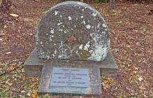
Stone Placed by Attleboro Historic CommissionGiven to the city of AttleborobyMr. and Mrs William A. Nerney1970
| HM Number | HM1DI7 |
|---|---|
| Tags | |
| Year Placed | 1970 |
| Placed By | Attleboro Historic Commission |
| Marker Condition |           8 out of 10 (1 reports) |
| Date Added | Wednesday, October 8th, 2014 at 3:22am PDT -07:00 |
| UTM (WGS84 Datum) | 19T E 310098 N 4646772 |
|---|---|
| Decimal Degrees | 41.95008333, -71.29115000 |
| Degrees and Decimal Minutes | N 41° 57.005', W 71° 17.469' |
| Degrees, Minutes and Seconds | 41° 57' 0.30" N, 71° 17' 28.14" W |
| Driving Directions | Google Maps |
| Area Code(s) | 401, 508, 617, 774 |
| Closest Postal Address | At or near 198 N Main St, Attleboro MA 02703, US |
| Alternative Maps | Google Maps, MapQuest, Bing Maps, Yahoo Maps, MSR Maps, OpenCycleMap, MyTopo Maps, OpenStreetMap |
Is this marker missing? Are the coordinates wrong? Do you have additional information that you would like to share with us? If so, check in.
I Could Not Find It
I photographed the marker and millstone, shuttle shop building stored behind the adjacent Knobby Crafters property and the Blackinton Pond dam where the shuttle shop was originally located. The Attleboro Parks & Forestry Depts. have been clearing out the underbrush and beautifying the landscape surround the pond and dam in the Blackinton Pond Park where the marker is located. The historic Col. Willard Blackinton home and Knobby Crafters factory is also for sale:
Oct 13, 2015 at 9:48am PDT by usjbh
- Is this marker part of a series?
- What historical period does the marker represent?
- What historical place does the marker represent?
- What type of marker is it?
- What class is the marker?
- What style is the marker?
- Does the marker have a number?
- Can this marker be seen from the road?
- Is the marker in the median?


Comments 0 comments