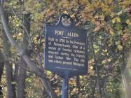
Inscription
1756-1922
Erected by Col. Benjamin Franklin in the winter of 1758 at the order of the Province of Pennsylvania. The fort consisting of the two block houses and a well. Surrounded by a stockade, was situated 201 feet southwest of this spot. It was used as a base of supplies and as a rendezvous for troops during the period of the French and Indian Wars. The well is the only trace left of the fort.Details
| HM Number | HM1MOI |
|---|---|
| Tags | |
| Placed By | The Improved Order of Red Men of Pennsylvania, the Public Schools of Carbon County |
| Marker Condition | No reports yet |
| Date Added | Sunday, August 9th, 2015 at 2:03pm PDT -07:00 |
Pictures
Photo Credits: [1] CAROLYN MARTIENSSEN
Locationbig map
| UTM (WGS84 Datum) | 18T E 440780 N 4520080 |
|---|---|
| Decimal Degrees | 40.82961667, -75.70233333 |
| Degrees and Decimal Minutes | N 40° 49.777', W 75° 42.14' |
| Degrees, Minutes and Seconds | 40° 49' 46.62" N, 75° 42' 8.4" W |
| Driving Directions | Google Maps |
| Area Code(s) | 610, 570, 484 |
| Closest Postal Address | At or near 108 Franklin St, Lehighton PA 18235, US |
| Alternative Maps | Google Maps, MapQuest, Bing Maps, Yahoo Maps, MSR Maps, OpenCycleMap, MyTopo Maps, OpenStreetMap |
Is this marker missing? Are the coordinates wrong? Do you have additional information that you would like to share with us? If so, check in.
Nearby Markersshow on map
Show me all markers in: Lehighton, PA | Carbon County | 18235 | Pennsylvania | United States of America
Fort Allen Well
Betty Mullen Brey
Jacob Weiss Memorial
The Hub in it's Heyday
Exploring the Corridor
Fort Allen
American Maritime Veterans Memorial, a War Memorial
War at Home Memorial, a War Memorial
World War I Centennial Commemoration, a War Memorial
Lehighton Area WWII Honored Dead Memorial, a War Memorial
Maintenance Issues
- Is this marker part of a series?
- What historical period does the marker represent?
- What historical place does the marker represent?
- What type of marker is it?
- What class is the marker?
- What style is the marker?
- Does the marker have a number?
- What year was the marker erected?
- This marker could use another picture or two.
- Can this marker be seen from the road?
- Is the marker in the median?

Comments 0 comments