Inscription
Take a moment to think about your home and family life. Thomas Harper and his wife Elizabeth raised six children in this home. Later, their son Richard and his wife Rachel raised fifteen children there. They kept chickens and pigs, had vegetable gardens and an orchard, and rounded out their homestead with a smokehouse and privy (pit toilet) since they had no electricity or indoor plumbing. Can you imagine your family living like the Harpers did so long ago'?
The cabin and smokehouse you see have not always been here at Brookside Nature Center. The cabin came from a freed slave community called Jonesville, just north of Poolesville, in Montgomery County. It was built in 1870 by Thomas Harper and remained in his family until 1935 when it was sold to Harry L. Willard. Mr. Willard's heirs donated the cabin to Montgomery Parks in 1976. It was dismantled, moved, and reassembled as part of the U.S. Bicentennial celebration. The 1850's smokehouse, originally from the Derwood area of Montgomery County was reconstructed here in 1975.
Over time, the Harper family added a full second floor and clapboard siding to their home. As the cabin was dismantled, different construction methods became evident — logs and chinking on the first floor 2 X 4 framing on the second. The cabin was reconstructed in its original form by Park
staff and volunteers.
As both structures were dismantled, the logs were labeled with metal tags (left) so the walls could be reassembled in their original form. The space between the logs would have been chinked with a mixture of stones, mud, hog hair, and glue. During reconstruction they were chinked with stones and cement for durability. The chimney, flooring, windows, and other aging parts of the cabin and smokehouse (right) were replaced.
Details
| HM Number | HM1Y13 |
|---|---|
| Tags | |
| Marker Condition | No reports yet |
| Date Added | Monday, April 24th, 2017 at 9:02am PDT -07:00 |
Pictures
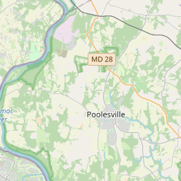
Locationbig map

| UTM (WGS84 Datum) | 18S E 324150 N 4325184 |
|---|---|
| Decimal Degrees | 39.05805000, -77.03236667 |
| Degrees and Decimal Minutes | N 39° 3.483', W 77° 1.942' |
| Degrees, Minutes and Seconds | 39° 3' 28.98" N, 77° 1' 56.52" W |
| Driving Directions | Google Maps |
| Area Code(s) | 301, 240, 410 |
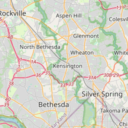
| Closest Postal Address | At or near Glenfield Rd, Silver Spring MD 20902, US |
| Alternative Maps | Google Maps, MapQuest, Bing Maps, Yahoo Maps, MSR Maps, OpenCycleMap, MyTopo Maps, OpenStreetMap |
Is this marker missing? Are the coordinates wrong? Do you have additional information that you would like to share with us? If so, check in.
Nearby Markersshow on map
Maintenance Issues
- Is this marker part of a series?
- What historical period does the marker represent?
- What historical place does the marker represent?
- What type of marker is it?
- What class is the marker?
- What style is the marker?
- Does the marker have a number?
- What year was the marker erected?
- Who or what organization placed the marker?
- This marker needs at least one picture.
- Can this marker be seen from the road?
- Is the marker in the median?
Comments 0 comments