Inscription
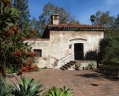
El Molino Viejo
The Old Mill, El Molino Viejo, was designed by Father José María Zalvidea and built of fired bricks and adobe about 1816 to serve Mission San Gabriel. Another grist mill was built in 1823 near the mission and the old mill was gradually abandoned - it passed from mission control in 1846. The property remained in private hands until 1903, when Henry E. Huntington bought the building and used it for a golf clubhouse. Later owners, Mr. and Mrs. James Brehm, had the mill restored in 1928 by Frederick Rupple.Details
| HM Number | HM257N |
|---|---|
| Additional Information | Open daily 1-4 except Mondays and holidays. Free admission. Park on the street and walk up the narrow driveway. This marker is missing. |
| Series | This marker is part of the California Historical Landmark series |
| Tags | |
| Historical Period | 19th Century |
| Historical Place | Mill |
| Marker Type | Historic Building |
| Marker Class | Historical Marker |
| Marker Style | Mounted |
| Marker Number | 302 |
| Placed By | California Historical |
| Marker Condition | No reports yet |
| Date Added | Saturday, February 3rd, 2018 at 3:41am PST -08:00 |
Pictures
Locationbig map
| Directions Information | At 1120 Old Mill Rd, San Marino, California 91108. |
|---|---|
| UTM (WGS84 Datum) | 11S E 396021 N 3775967 |
| Decimal Degrees | 34.11938710, -118.12749750 |
| Degrees and Decimal Minutes | N 34° 7.1632', W 118° 7.6499' |
| Degrees, Minutes and Seconds | 34° 7' 9.7936" N, 118° 7' 38.9910" W |
| Driving Directions | Google Maps |
| Area Code(s) | 626, 323 |
| Can be seen from road? | Yes |
| Is marker in the median? | No |
| Which side of the road? | Marker is on the right when traveling West |
| Closest Postal Address | At or near 1120 Old Mill Rd, San Marino CA 91108, US |
| Alternative Maps | Google Maps, MapQuest, Bing Maps, Yahoo Maps, MSR Maps, OpenCycleMap, MyTopo Maps, OpenStreetMap |
Is this marker missing? Are the coordinates wrong? Do you have additional information that you would like to share with us? If so, check in.
Nearby Markersshow on map


Comments 0 comments