Inscription
Wetlands are described simply as any area that floods regularly and supports plants that are adapted to flooding. Wetlands have been disappearing at an alarming rate in the United States and elsewhere. For example, although Louisiana only accounts for 12 percent of the continental coastal wetlands, it is currently experiencing 80 percent of the total coastal wetlands less. That amounts to 25-35 square miles lost every year! The Nature Conservancy works across Louisiana and the nation to protect and restore declining wetlands. Wetlands are now protected by law because they are ecologically important, and because they perform a variety of useful functions. Wetlands provide wildlife habitat, absorb excess nutrients and pollutants, purify water, trap sediments, temporarily store floodwaters, and recharge groundwater reserves. Wetlands serve as nurseries for commercially and recreationally important fish and provide habitat for nearly 50 percent of the nation's threatened and endangered animals. Cypress Island is the largest forested wetland tract in the Bayou Teche/Vermilion River Basin. Cypress Island Preserve provides wetland habitat for a large wading. bird rookery in the southern portion of Lake Martin. The rookery supports more than 20,000 pairs of birds during peak nesting season (April-May), including Great Egrets, Snowy
Egrets, Little Blue Herons, Cattle Egrets, Yellow-crowned Night-Herons, and Roseate Spoonbills. There are many kinds of wetlands in Louisiana, including cypress- tupelo swamps, freshwater and saltwater marshes, bottomland hardwood forests, and pine savannas.
Egrets, Little Blue Herons, Cattle Egrets, Yellow-crowned Night-Herons, and Roseate Spoonbills. There are many kinds of wetlands in Louisiana, including cypress- tupelo swamps, freshwater and saltwater marshes, bottomland hardwood forests, and pine savannas.
Details
| HM Number | HM25QD |
|---|---|
| Tags | |
| Placed By | The Nature Conservancy of Louisiana |
| Marker Condition | No reports yet |
| Date Added | Wednesday, February 28th, 2018 at 7:01pm PST -08:00 |
Pictures
Locationbig map

| UTM (WGS84 Datum) | 15R E 605807 N 3341849 |
|---|---|
| Decimal Degrees | 30.20353333, -91.90073333 |
| Degrees and Decimal Minutes | N 30° 12.212', W 91° 54.044' |
| Degrees, Minutes and Seconds | 30° 12' 12.72" N, 91° 54' 2.6399999999998" W |
| Driving Directions | Google Maps |
| Area Code(s) | 318, 337 |
| Which side of the road? | Marker is on the right when traveling West |
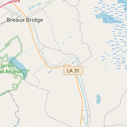
| Closest Postal Address | At or near 1000 Rookery Rd, Breaux Bridge LA 70517, US |
| Alternative Maps | Google Maps, MapQuest, Bing Maps, Yahoo Maps, MSR Maps, OpenCycleMap, MyTopo Maps, OpenStreetMap |
Is this marker missing? Are the coordinates wrong? Do you have additional information that you would like to share with us? If so, check in.
Nearby Markersshow on map
Show me all markers in: Breaux Bridge, LA | St. Martin Parish | 70517 | Louisiana | United States of America
Maintenance Issues
- Is this marker part of a series?
- What historical period does the marker represent?
- What historical place does the marker represent?
- What type of marker is it?
- What class is the marker?
- What style is the marker?
- Does the marker have a number?
- What year was the marker erected?
- This marker needs at least one picture.
- Can this marker be seen from the road?
- Is the marker in the median?
Comments 0 comments