Inscription
City of Alexandria Est. 1749
—Potomac Yard —
Certain rail classification yards depended on a simple landform called the "hump." Potomac Yard had two humps: one for the northbound trains and one for the southbound trains. Trains first entered a receiving yard where locomotives were detached from trains and cars were sent to a classification yard over the hump: a hill built between the two yards. After being pushed to the top of the hump by a yard locomotive, cars were uncoupled in specific groups and allowed to roll down one of several different tracks to become part of a new train. This group of tracks formed the classification yard. This system used gravity—and a good deal of pre-planning by track managers—to make classifying (or sorting) rail cars much easier.Technological Advances
Potomac Yard incorporated numerous technological advances over the years to improve efficiency. Classifying cars evolved from primarily manual labor to utilizing automated and digital systems. Computers, installed at the Yard in the 1960s and 1970s, replaced mechanical relay systems with state-of-the-art digital systems.
The first hump yards at Potomac Yard were operated manually by car-cutters who uncoupled the cars when they reached the top of the hump. Switch tenders lined the switches and brakemen rode the cars down the hill and slowed their descent
using hand-operated brakes. In the 1930s and 1940s, remotely-operated switches and car retarders were installed and controlled from two towers on each hump.
In the late 1950s, the hump yards were once again updated when the VELAC system was installed at the southbound hump. VELAC, an automated classification yard system, replaced remote switches with electronic switches controlled from a four-story concrete tower. Touted as an "electronic brain," VELAC made car classification even more efficient and required fewer employees.
Details
| HM Number | HM26GX |
|---|---|
| Tags | |
| Placed By | City of Alexandria |
| Marker Condition | No reports yet |
| Date Added | Sunday, April 1st, 2018 at 7:02am PDT -07:00 |
Pictures
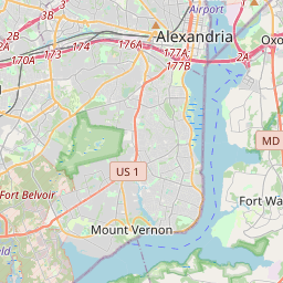
Locationbig map

| UTM (WGS84 Datum) | 18S E 322162 N 4299082 |
|---|---|
| Decimal Degrees | 38.82258333, -77.04855000 |
| Degrees and Decimal Minutes | N 38° 49.355', W 77° 2.913' |
| Degrees, Minutes and Seconds | 38° 49' 21.3" N, 77° 2' 54.78" W |
| Driving Directions | Google Maps |
| Area Code(s) | 202, 703, 571 |
| Which side of the road? | Marker is on the right when traveling North |
| Closest Postal Address | At or near Potomac Yard Trail, Alexandria VA 22314, US |
| Alternative Maps | Google Maps, MapQuest, Bing Maps, Yahoo Maps, MSR Maps, OpenCycleMap, MyTopo Maps, OpenStreetMap |
Is this marker missing? Are the coordinates wrong? Do you have additional information that you would like to share with us? If so, check in.
Nearby Markersshow on map
Maintenance Issues
- Is this marker part of a series?
- What historical period does the marker represent?
- What historical place does the marker represent?
- What type of marker is it?
- What class is the marker?
- What style is the marker?
- Does the marker have a number?
- What year was the marker erected?
- This marker needs at least one picture.
- Can this marker be seen from the road?
- Is the marker in the median?
Comments 0 comments