Inscription
In 1892, William Edward Geoffrey, an African American man from Darlington, South Carolina, came to work on the Florida East Coast Railroad in Gifford. The town's first school was built in 1898, but only served white children. In 1901, Geoffrey purchased eighty acres of land in Gifford, and donated a portion for a park and the construction of a black school. Named the Gifford School, the small building was located at 38th Lane, east of what is now US Highway 1. The school originally taught students in first through sixth grades. Older students had to travel to Fort Pierce to attend high school. In 1938, the Gifford School expanded to include a high school. In 1952, the Indian River County Board funded the construction of a new high school building at 45th Street and 28th Court. Following the integration of Indian River County schools in 1969, Gifford High School graduated its last class and became a middle school. The original facade is now part of the Gifford Middle School campus. This sundial was presented as a gift from the Class of 1964 upon their graduation. This facade and sundial are the last material remnants of the original Gifford High School.
Details
| HM Number | HM2D1R |
|---|---|
| Tags | |
| Year Placed | 2017 |
| Placed By | Gifford High School Alumni and Friends Association, Gifford Community Cultural and Resource Center, Gifford Historic Museum, Dr. MLK, Jr Committee, Gifford Progressive Civic League, Indian River County Historical Society, and the Florida Department of State |
| Marker Condition | No reports yet |
| Date Added | Wednesday, December 26th, 2018 at 10:01am PST -08:00 |
Pictures
Locationbig map


| UTM (WGS84 Datum) | 17R E 557899 N 3061355 |
|---|---|
| Decimal Degrees | 27.67515000, -80.41288333 |
| Degrees and Decimal Minutes | N 27° 40.509', W 80° 24.773' |
| Degrees, Minutes and Seconds | 27° 40' 30.54" N, 80° 24' 46.38" W |
| Driving Directions | Google Maps |
| Area Code(s) | 772 |
| Which side of the road? | Marker is on the right when traveling West |
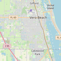
| Closest Postal Address | At or near 2731 45th St, Vero Beach FL 32967, US |
| Alternative Maps | Google Maps, MapQuest, Bing Maps, Yahoo Maps, MSR Maps, OpenCycleMap, MyTopo Maps, OpenStreetMap |
Is this marker missing? Are the coordinates wrong? Do you have additional information that you would like to share with us? If so, check in.
Nearby Markersshow on map
Show me all markers in: Vero Beach, FL | Indian River County | 32967 | Florida | United States of America
Maintenance Issues
- Is this marker part of a series?
- What historical period does the marker represent?
- What historical place does the marker represent?
- What type of marker is it?
- What class is the marker?
- What style is the marker?
- Does the marker have a number?
- This marker needs at least one picture.
- Can this marker be seen from the road?
- Is the marker in the median?
Comments 0 comments