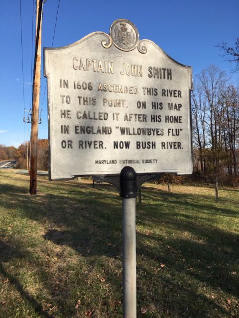
Inscription
Captain John Smith in 1608 ascended this river to this point. On his map he called it after his home in England "Willowbyes Flu" or river. Now Bush River.
Details
| HM Number | HM51 |
|---|---|
| Tags | |
| Historical Period | 17th Century |
| Historical Place | Other |
| Marker Type | Historic District |
| Marker Class | Historical Marker |
| Marker Style | Free Standing |
| Placed By | Maryland Historical Society |
| Marker Condition | No reports yet |
| Date Added | Saturday, September 20th, 2014 at 2:08am PDT -07:00 |
Pictures


Locationbig map
| UTM (WGS84 Datum) | 18S E 389956 N 4367473 |
|---|---|
| Decimal Degrees | 39.44980000, -76.27895000 |
| Degrees and Decimal Minutes | N 39° 26.988', W 76° 16.737' |
| Degrees, Minutes and Seconds | 39° 26' 59.2800" N, 76° 16' 44.2200" W |
| Driving Directions | Google Maps |
| Area Code(s) | 410, 443 |
| Can be seen from road? | Yes |
| Is marker in the median? | No |
| Which side of the road? | Marker is on the right when traveling West |
| Closest Postal Address | At or near 3025 Pulaski Hwy, Edgewood MD 21040, US |
| Alternative Maps | Google Maps, MapQuest, Bing Maps, Yahoo Maps, MSR Maps, OpenCycleMap, MyTopo Maps, OpenStreetMap |
Is this marker missing? Are the coordinates wrong? Do you have additional information that you would like to share with us? If so, check in.
Nearby Markersshow on map
Maintenance Issues
- Is this marker part of a series?
Comments 0 comments