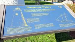
Inscription
On the point where the mighty Susquehanna River meets the Chesapeake Bay stands the lighthouse that protected vessels from dangerous waters for 148 years.
Built in 1827 to protect vessels from dangerous shoals and currents at the mouth of the Susquehanna River, the Concord Point Lighthouse served faithfully until it was decommissioned by the U.S. Coast Guard in 1975. In 1979, The Friends of Concord Point Lighthouse formed to preserve the lighthouse and keep a light burning in the tower.
The lighthouse was built by a prominent lighthouse contractor, John Donohoo. Donohoo, a native of Harford County, built 12 of the first Chesapeake Bay lighthouses. Donohoo also served as Havre de Grade town commissioner in the early 1800s.
The lighthouse is built from Port Deposit granite and has an unusual black 9 sided lantern. The stone walls at the base of the tower are 3 feet 11 inches thick and the tower is 36 feet tall. The light could be seen 8½ miles away. Originally lit with 9 whale oil lamps, the light became electrified and automated in 1920. This lighthouse was very well built and has needed few repairs over the years.
At the end of the Revolutionary War, the town of Havre de Grace renamed many of its streets to celebrate. Concord Street was named for the first victory of the war, the battle of Concord in 1775. And so, the lighthouse, which stands at the end of Concord Street on a point was named Concord Point Lighthouse.
In the 1800s, keel boats traveling down the Susquehanna River with goods to sell and bay schooners sailing up the bay were at risk here. These boats were made of wood and could easily break on the rocks at the mouth of the river. This lighthouse safeguarded the heavy merchant traffic of this area.
Details
| HM Number | HMAK |
|---|---|
| Tags | |
| Historical Period | 19th Century |
| Historical Place | Other |
| Marker Type | Historic Building |
| Marker Class | Historical Marker |
| Marker Style | Free Standing |
| Marker Condition | No reports yet |
| Date Added | Saturday, September 20th, 2014 at 3:19pm PDT -07:00 |
Pictures
Photo Credits: [1] SEPTEMBERSPARROW1666
Locationbig map
| UTM (WGS84 Datum) | 18S E 406749 N 4377352 |
|---|---|
| Decimal Degrees | 39.54078333, -76.08520000 |
| Degrees and Decimal Minutes | N 39° 32.447', W 76° 5.112' |
| Degrees, Minutes and Seconds | 39° 32' 26.8200" N, 76° 5' 6.7200" W |
| Driving Directions | Google Maps |
| Area Code(s) | 443, 410 |
| Can be seen from road? | No |
| Is marker in the median? | No |
| Closest Postal Address | At or near 701 Concord St, Havre de Grace MD 21078, US |
| Alternative Maps | Google Maps, MapQuest, Bing Maps, Yahoo Maps, MSR Maps, OpenCycleMap, MyTopo Maps, OpenStreetMap |
Is this marker missing? Are the coordinates wrong? Do you have additional information that you would like to share with us? If so, check in.
Nearby Markersshow on map
Show me all markers in: Havre de Grace, MD | Harford County | 21078 | Maryland | United States of America
Maintenance Issues
- Is this marker part of a series?
- Who or what organization placed the marker?
- This marker could use another picture or two.
- Which side of the road is the marker located?

Comments 0 comments