Inscription
Each night he left his house to climb the 27 stairs and 6 rung iron ladder to the top of the lighthouse. And he did this three times a night to refill the oil that kept the light burning and the ships safe.
This is the house of the Keeper of the Light, built in 1827, just after the Concord Point Lighthouse was built. The same man who built the lighthouse, John Donohoo, also built the house. The original plans called for a solid, simple house 34 feet by 20 feet with an attached kitchen.
All of the original house but the kitchen still stands. Though many changes have taken place since 1827. In 1884 an additional story was added to the house. At other times interior changes and the addition of outbuildings altered the original house.
In 1920, when the lighthouse became automated with electricity, the house was sold and became a private home. Later, the home was turned into a restaurant with a dance hall. In 1988, the State of Maryland purchased the house and gave it to the City of Havre de Grace. The Friends of Concord Point Lighthouse began restoring the house in 1990.
Keepers of the Light.Since 1827, when the Concord Point Lighthouse was commissioned, many different Keepers ensured that the light burned bright. The first Keeper of the Light was John O'Neill who served until his death in 1838. O'Neill was a town hero who fought bravely against British ships when they attacked Havre de Grace on May 3, 1813. O'Neill served as Havre de Grace town commissioner from 1829 to 1835. John O'Neill's descendants continued to live in the lighthouse and several served as Keepers until the lighthouse became automated in 1920.
Details
| HM Number | HMHR |
|---|---|
| Tags | |
| Historical Period | 19th Century |
| Historical Place | Home |
| Marker Type | Historic Building |
| Marker Class | Historical Marker |
| Marker Style | Free Standing |
| Marker Condition | No reports yet |
| Date Added | Thursday, October 2nd, 2014 at 12:57am PDT -07:00 |
Pictures
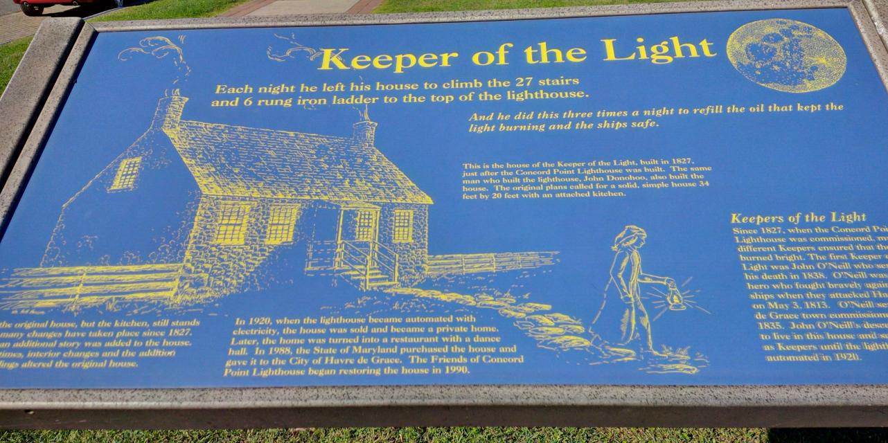
Photo Credits: [1] SEPTEMBERSPARROW1666
Locationbig map
| UTM (WGS84 Datum) | 18S E 406749 N 4377352 |
|---|---|
| Decimal Degrees | 39.54078333, -76.08520000 |
| Degrees and Decimal Minutes | N 39° 32.447', W 76° 5.112' |
| Degrees, Minutes and Seconds | 39° 32' 26.8200" N, 76° 5' 6.7200" W |
| Driving Directions | Google Maps |
| Area Code(s) | 443, 410 |
| Can be seen from road? | Yes |
| Is marker in the median? | No |
| Which side of the road? | Marker is on the right when traveling South |
| Closest Postal Address | At or near 701 Concord St, Havre de Grace MD 21078, US |
| Alternative Maps | Google Maps, MapQuest, Bing Maps, Yahoo Maps, MSR Maps, OpenCycleMap, MyTopo Maps, OpenStreetMap |
Is this marker missing? Are the coordinates wrong? Do you have additional information that you would like to share with us? If so, check in.
Nearby Markersshow on map
Show me all markers in: Havre de Grace, MD | Harford County | 21078 | Maryland | United States of America
Related Markers
Maintenance Issues
- Is this marker part of a series?
- Who or what organization placed the marker?
- This marker could use another picture or two.
Comments 0 comments