Inscription
Lawrence was established in 1854 by the Emigrant Aid Company, a New England organization formed to prevent the new Kansas territory from becoming a slave state. When the first legislature enacted the so-called Bogus Laws with severe penalties for opposing slavery Lawrence was the center of Free-State resistance. Free-State newspapers here further antagonized Proslavery officers. Late in 1855 1500 Proslavery men gathered to attack the town. Free-State men came to its defense, among them John Brown. Bloodshed was averted by a "Peace Treaty." The next spring, however, a "sheriff's posse" of several hundred Missourians burned houses, destroyed two newspaper Presses and fired a cannon into the Eldridge Hotel on the pretext that it was an Abolition Fort.
During the Civil War Lawrence was a haven for runway slaves and was held responsible for Union raids into Missouri. On August 21, 1863, Quantrill and a band of guerrillas ravaged the town and killed nearly 150 men. Monuments to these victims and other historical markers may be seen in the city. Lawrence is home of the University of Kansas and Haskell Indian Institute.
During the Civil War Lawrence was a haven for runway slaves and was held responsible for Union raids into Missouri. On August 21, 1863, Quantrill and a band of guerrillas ravaged the town and killed nearly 150 men. Monuments to these victims and other historical markers may be seen in the city. Lawrence is home of the University of Kansas and Haskell Indian Institute.
Details
| HM Number | HMDH5 |
|---|---|
| Series | This marker is part of the Kansas: Kansas Historical Society series |
| Tags | |
| Marker Number | 10 |
| Placed By | Kansas Historical Society and State Highway Commission |
| Marker Condition | No reports yet |
| Date Added | Saturday, October 4th, 2014 at 2:41pm PDT -07:00 |
Pictures
Locationbig map


| UTM (WGS84 Datum) | 15S E 306029 N 4316203 |
|---|---|
| Decimal Degrees | 38.97335000, -95.23910000 |
| Degrees and Decimal Minutes | N 38° 58.401', W 95° 14.346' |
| Degrees, Minutes and Seconds | 38° 58' 24.06" N, 95° 14' 20.76" W |
| Driving Directions | Google Maps |
| Area Code(s) | 785, 913 |
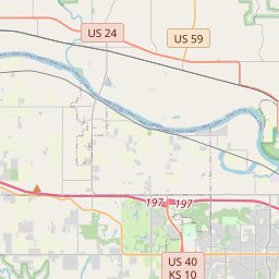
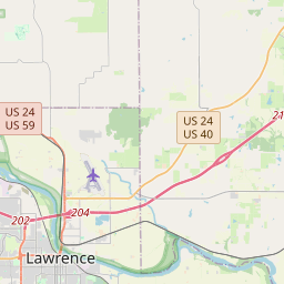
| Closest Postal Address | At or near 4000 Bostwick Rd, Lawrence KS 66044, US |
| Alternative Maps | Google Maps, MapQuest, Bing Maps, Yahoo Maps, MSR Maps, OpenCycleMap, MyTopo Maps, OpenStreetMap |
Is this marker missing? Are the coordinates wrong? Do you have additional information that you would like to share with us? If so, check in.
Nearby Markersshow on map
Maintenance Issues
- What historical period does the marker represent?
- What historical place does the marker represent?
- What type of marker is it?
- What class is the marker?
- What style is the marker?
- What year was the marker erected?
- This marker needs at least one picture.
- Can this marker be seen from the road?
- Is the marker in the median?
Comments 0 comments