Inscription
Formed by erosion of Cleveland shale and cascading 48 feet, making it the tallest waterfall in the county, the Cataract Falls of Mill Creek powered the gristmill and sawmill built by William Wheeler Williams and Major Wyatt in 1799. The mills, commissioned by the Connecticut Land Company to encourage settlement of the Western Reserve, attracted people to Newburgh. Cleveland finally outgrew bustling Newburgh by 1830 and eventually annexed most of it. The founding of the Cleveland Rolling Mill in Newburgh, beginning with the firm of Chisholm, Jones, & Company in 1857, precipitated the growth of the steel industry in Cleveland. By 1868, under the management of Henry Chisholm, it became one of the first in the nation to produce steel using the Bessemer process. The Rolling Mill, later the American Steel and Wire Company (a subsidiary of U.S. Steel), purchased the millworks at the falls in 1872.
Details
| HM Number | HMDW5 |
|---|---|
| Series | This marker is part of the Ohio: Ohio Historical Society series |
| Tags | |
| Marker Number | 33-18 |
| Year Placed | 2002 |
| Placed By | Ohio Bicentennial Commission, The Longaberger Company, Cleveland Metroparks, Williams-Swain Family, and The Ohio Historical Society |
| Marker Condition | 0 out of 10 (1 reports) |
| Date Added | Tuesday, September 16th, 2014 at 12:24am PDT -07:00 |
Pictures
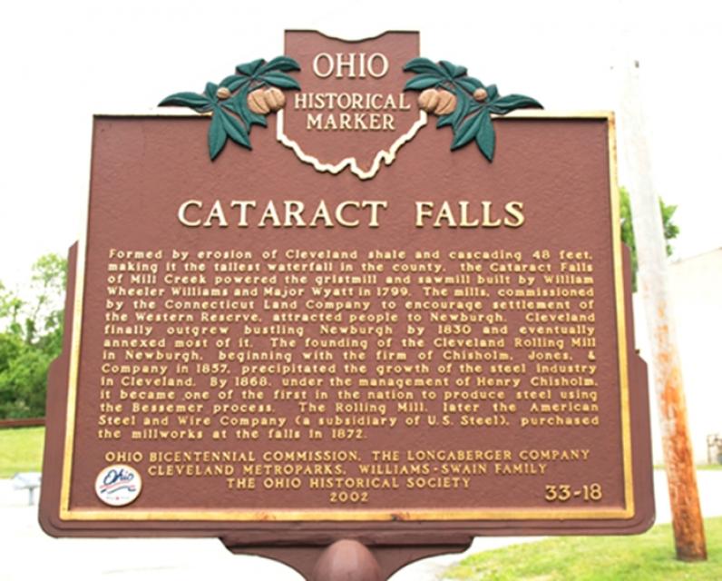
Photo Credits: [1] MARSHA BILLER
Locationbig map
| UTM (WGS84 Datum) | 17T E 447731 N 4588317 |
|---|---|
| Decimal Degrees | 41.44473333, -81.62571667 |
| Degrees and Decimal Minutes | N 41° 26.684', W 81° 37.543' |
| Degrees, Minutes and Seconds | 41° 26' 41.04" N, 81° 37' 32.58" W |
| Driving Directions | Google Maps |
| Area Code(s) | 216 |
| Closest Postal Address | At or near 501-505 Mill Creek Trail, Cleveland OH 44105, US |
| Alternative Maps | Google Maps, MapQuest, Bing Maps, Yahoo Maps, MSR Maps, OpenCycleMap, MyTopo Maps, OpenStreetMap |
Is this marker missing? Are the coordinates wrong? Do you have additional information that you would like to share with us? If so, check in.
Nearby Markersshow on map
I Saw The Marker
It is easily identified right in front of the overlook to the falls
Jun 9, 2017 at 2:09pm PDT by soulcatcher
Maintenance Issues
- What historical period does the marker represent?
- What historical place does the marker represent?
- What type of marker is it?
- What class is the marker?
- What style is the marker?
- This marker could use another picture or two.
- Can this marker be seen from the road?
- Is the marker in the median?
Comments 0 comments