Inscription
Gettysburg Campaign
Following a night of harassing the Confederate wagon train retreating from Gettysburg, Gen. H. Judson Kilpatrick's Union cavalry division arrived here about 9 a.m. on July 5, 1963, escorting 1,360 prisoners. Wet, tired, hungry, and covered with mud, the Federal horsemen received a jubilant Sunday reception from the citizens. Tables suddenly appeared in the streets, covered with plates of fresh bread, jellies, spreads, meats, and pies. Soldiers butchered and barbecued a cow. Gen. George A. Custer enjoyed a bountiful dinner of chicken and all the trimmings. A local band played patriotic songs such as Hail Columbia and Yankee Doodle. "It was like an oasis in the desert," reported one Federal soldier, "a green spot in the soldier's life."
Aware that Confederate cavalry lurked nearby, Kilpatrick placed guns and troopers on the three hills that commanded approaches to the town, with orders to watch the Raven Rock Road descending from South Mountain. When the van of Confederate J.E.B. Stuart's cavalry column appeared that afternoon, Stuart had to "dismount a large portion of the command, and fight from crag to crag of the mountains to dislodge the enemy."
After driving off the skirmishers, Stuart set up artillery a mile from the town. A twenty-minute exchange of cannon fire then ensued, and Confederate shells struck several houses in Smithsburg. The action ended at nightfall, with each side suffering few casualties. Kilpatrick withdrew south toward Boonsboro, while Stuart's men fanned out to protect Confederate retreat routes leading to Williamsport and the Potomac River.
Details
| HM Number | HMNB |
|---|---|
| Series | This marker is part of the Maryland Civil War Trails series |
| Tags | |
| Historical Period | Civil War |
| Historical Place | Battlefield |
| Marker Type | Other |
| Marker Class | Historical Marker |
| Marker Style | Interpretative Marker / Sign |
| Placed By | Maryland Civil War Trails |
| Marker Condition | No reports yet |
| Date Added | Saturday, September 6th, 2014 at 2:20am PDT -07:00 |
Pictures
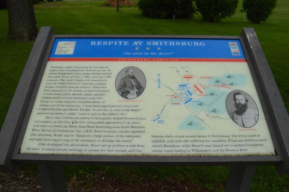
Photo Credits: [1] DOUGLAS MOWEN
Locationbig map
| UTM (WGS84 Datum) | 18S E 278803 N 4392425 |
|---|---|
| Decimal Degrees | 39.65318000, -77.57825700 |
| Degrees and Decimal Minutes | N 39° 39.1908', W 77° 34.6954' |
| Degrees, Minutes and Seconds | 39° 39' 11.4480" N, 77° 34' 41.7252" W |
| Driving Directions | Google Maps |
| Area Code(s) | 301, 240 |
| Can be seen from road? | No |
| Closest Postal Address | At or near 62 W Water St, Smithsburg MD 21783, US |
| Alternative Maps | Google Maps, MapQuest, Bing Maps, Yahoo Maps, MSR Maps, OpenCycleMap, MyTopo Maps, OpenStreetMap |
Is this marker missing? Are the coordinates wrong? Do you have additional information that you would like to share with us? If so, check in.
Nearby Markersshow on map
Show me all markers in: Smithsburg, MD | Washington County | 21783 | Maryland | United States of America
Gettysburg Campaign
Smithsburg Veterans Memorial, a War Memorial
Memorial to World War II Korea and Vietnam Veterans of Smithsburg and Community, a War Memorial
Memorial to World War One Veterans of Smithsburg and Community, a War Memorial
Officer Christopher Shane Nicholson
"Stuffle" Christopher Smith
Battle of Smithsburg
Gettysburg Campaign
Gettysburg Campaign (Leitersburg)
Retreat into Maryland (Leitersburg)
Maintenance Issues
- This marker could use another picture or two.
- Is the marker in the median?
Comments 0 comments