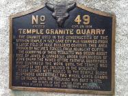
The quarrying of these boulders was begun about 1862 by James C. Livingston, under supervision of John Sharp. The names of the faithful quarrymen who continued the work until the temple was finished in 1893 are enclosed in the monument.
Rough stones were hauled to the temple block suspended under great two wheeled carts drawn by ox-teams, until the railroad was built in 1872.
| HM Number | HMTNT |
|---|---|
| Series | This marker is part of the Utah Pioneer Trails and Landmarks Association series |
| Tags | |
| Historical Period | 19th Century |
| Historical Place | Monument |
| Marker Type | Historic District |
| Marker Class | Historical Marker |
| Marker Style | Free Standing |
| Marker Number | 49 |
| Year Placed | 1934 |
| Placed By | Boy Scouts of East Jordan Stake and Utah Pioneer Trails and Landmarks Association |
| Marker Condition |           10 out of 10 (2 reports) |
| Date Added | Monday, September 8th, 2014 at 6:10am PDT -07:00 |
| Directions Information | Turn right off of road 209 just before it converges with road 210 at the mouth of Little Cottonwood Canyon. |
|---|---|
| UTM (WGS84 Datum) | 12T E 434392 N 4491531 |
| Decimal Degrees | 40.57196667, -111.77510000 |
| Degrees and Decimal Minutes | N 40° 34.318', W 111° 46.506' |
| Degrees, Minutes and Seconds | 40° 34' 19.0800" N, 111° 46' 30.3600" W |
| Driving Directions | Google Maps |
| Area Code(s) | 801 |
| Can be seen from road? | No |
| Is marker in the median? | No |
| Which side of the road? | Marker is on the right when traveling East |
| Closest Postal Address | At or near Temple Quarry Path, Sandy UT 84092, US |
| Alternative Maps | Google Maps, MapQuest, Bing Maps, Yahoo Maps, MSR Maps, OpenCycleMap, MyTopo Maps, OpenStreetMap |
Is this marker missing? Are the coordinates wrong? Do you have additional information that you would like to share with us? If so, check in.
I Saw The Marker
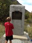
This Temple Granite Quarry monument is located at the west end of the parking lot. The Temple Stone Quarry informational plaque is found nearby on the .3 mile paved loop trail.
Oct 17, 2015 at 9:26pm PDT by jaimeclem
Something Else
This monument marker is listed twice - as the Temple Stone Quarry and the Temple Granite Quarry.
The name on the monument is the Temple Granite Quarry.
Oct 17, 2015 at 8:14pm PDT by jaimeclem
- This marker could use another picture or two.


Comments 0 comments